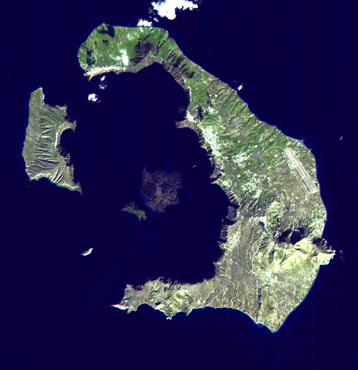
The island was called Strongili before the eruption — Greek for "the round one." It was a fertile volcanic island in the southern Cyclades, sitting 110 kilometres north of Crete at the center of the Bronze Age Aegean trade world. It had a thriving port city on its southern shore, a population that built in stone, painted their walls, and ran clean water through pipes inside their houses. Then, sometime around 1600 BC, the magma chamber beneath the island emptied in a single catastrophic event, the central landmass collapsed into the sea, and everything above was buried under meters of pumice and ash.
What remains of Strongili today is the crescent of islands the Greeks call Santorini: a dramatic arc of clifftop towns overlooking a flooded caldera twelve kilometres across, the hollow shell of a world that ended in an afternoon.
The Eruption
The Minoan eruption unfolded in at least four phases. It began with a massive Plinian column of ash and pumice rising 35 to 40 kilometres into the stratosphere, blanketing the island and the surrounding sea. Pyroclastic surges followed: fast-moving currents of hot gas and rock that swept across the surface. Then came the caldera collapse, when the emptied magma chamber beneath could no longer support the island's weight and the center dropped into the void, sending the largest waves of the eruption radiating outward across the Aegean.
By any measure, this was one of the largest volcanic eruptions in the entire Holocene. Its Volcanic Explosivity Index rating is 6 to 7, with most volcanologists settling on 7. The eruption ejected roughly 34 cubic kilometres of dense-rock equivalent material, or more than 60 cubic kilometres in bulk volume when accounting for the porous, aerated nature of pumice and ash. For comparison, Krakatoa's 1883 eruption — which killed 36,000 people and was heard 4,800 kilometres away — was a fraction of this scale.
Ash from Thera has been found in cores drilled from the Nile Delta, in sediment layers off the coast of Cyprus, and in Greenland ice sheets more than 3,000 kilometres away.
The Eruption
Island: Thera (modern Santorini), southern Cyclades, Aegean Sea
Date: approximately 1600 BC (scientific dating); ~1500 BC (archaeological dating)
VEI rating: 6–7 (one of the largest in the Holocene)
Volume: ~34 km³ dense-rock equivalent; ~60+ km³ bulk
Plume height: 35–40 km (stratospheric)
Caldera formed: ~12 km across, up to 400 m deep, now sea-filled
Tsunamis: 7–15 metres height at Cretan coastline
The City Under the Ash
Workers quarrying the volcanic ash from Santorini's cliffs in the 1860s — the material was used as hydraulic cement in the construction of the Suez Canal — kept finding walls and pottery. The Greek archaeologist Spyridon Marinatos suspected something significant was buried there. In 1967, he began the systematic excavation that proved him right.
The city that emerged from the pumice is called Akrotiri, and it is one of the best-preserved Bronze Age settlements ever found. Buildings of two and three storeys still stand to their original height. Stone stairways survive intact. Plaster walls retain their colors. Storage jars still hold traces of grain, oil, and fish remains. Pottery was found stacked on shelves exactly where it had been left.
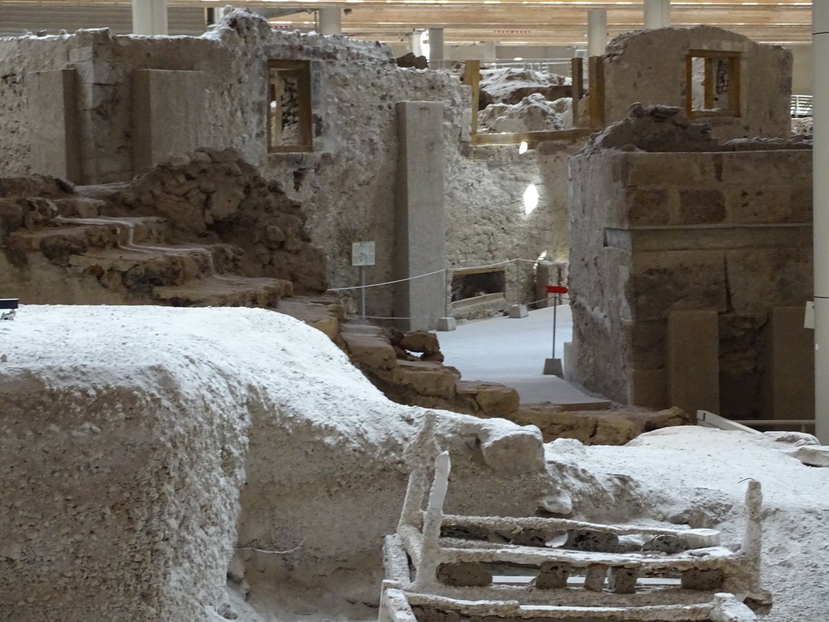
Most remarkably, Akrotiri had indoor plumbing in 1600 BC. Pipes and drains were built into the walls, carrying water in and waste out in a system with no close parallel in the Bronze Age world. The streets were paved. Plaster casts made from furniture-shaped voids in the hardened ash have revealed beds, tables, and wooden storage containers — the ghost inventory of a household that left in an organized hurry.
There are no human remains. Despite decades of excavation across a substantial area of the city, archaeologists have found almost no human bones anywhere at Akrotiri. Only one gold object has been recovered from the entire site: a small golden ibex figurine. Everything else of value appears to have been taken.
The explanation is almost certainly seismic warning. Major volcanic eruptions are typically preceded by earthquake swarms as the magma forces its way toward the surface. The residents of Akrotiri would have felt those earthquakes, possibly for weeks or months before the main event. They appear to have organized a systematic evacuation: loading their valuables onto boats, leaving behind what they could not carry, and sailing away from an island that was about to stop existing. Where they went is unknown. No group of Theran refugees has been identified in the archaeological record of any neighboring region.
What Was Left on the Walls
The frescoes of Akrotiri are among the most extraordinary survivals of the Bronze Age. Protected under the ash for 3,600 years, their mineral pigments have retained a freshness that modern artists have found startling.
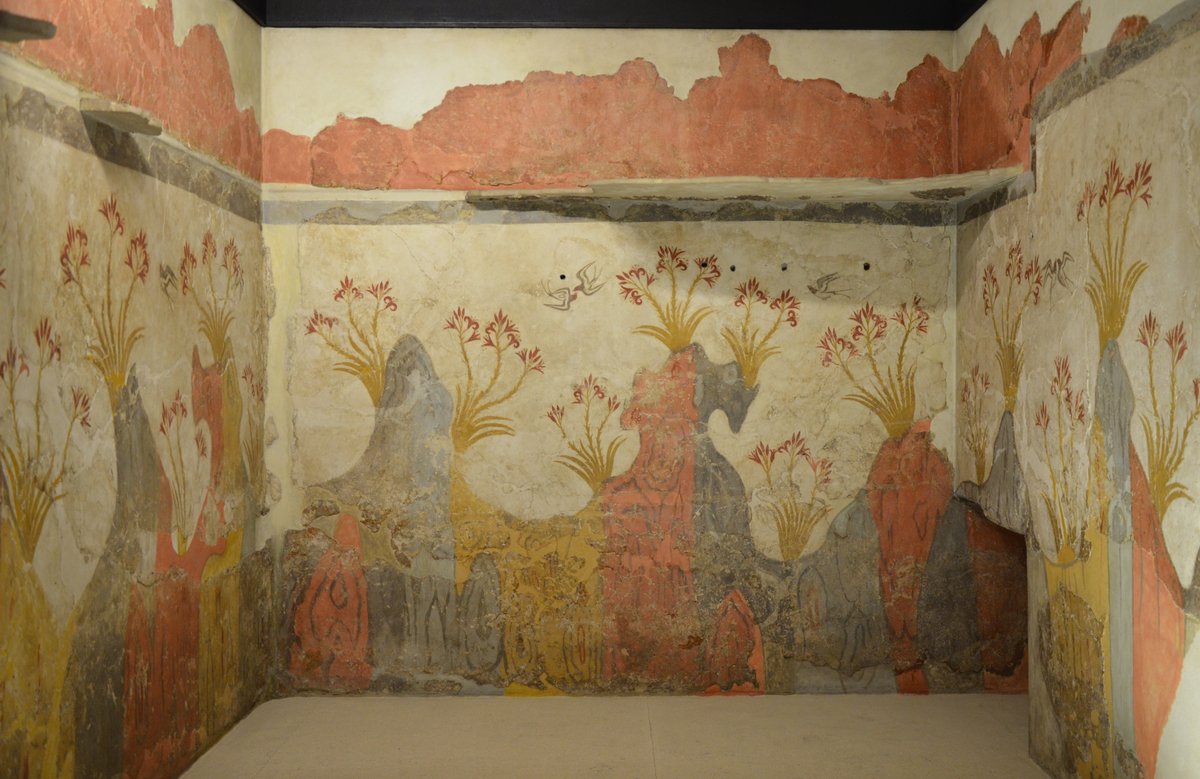
The Spring Fresco, found covering three walls of a small room, shows crimson lilies growing from red volcanic rocks with swallows flying between them. It is one of the earliest known landscape paintings in the Western world: a pure nature scene with no human figures, no religious symbols, no narrative. It is simply spring on a volcanic island, rendered in 1600 BC with a freshness that feels immediately modern.
The Boxing Boys fresco shows two children facing each other with a boxing glove on each right hand — one of the earliest depictions of organized athletics anywhere on Earth. The Flotilla Fresco, which wraps around three walls of an upper-storey room, depicts a fleet of 14 ships sailing between two port cities in miniature detail: crowds on the shore, dolphins leaping alongside the vessels, buildings and landscapes in continuous panorama. It is one of the oldest narrative paintings ever found, and a window into the maritime world that the Thera eruption destroyed.
The Civilization It May Have Ended
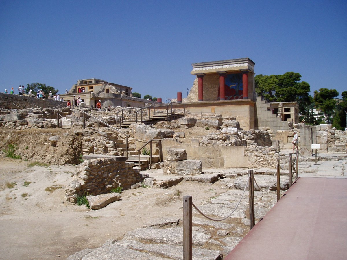
The people who built Akrotiri were part of the broader Minoan world: a Bronze Age civilization centered on the island of Crete, 110 kilometres to the south. The Minoans were, by every measure, the dominant power of the ancient Aegean. Their palaces at Knossos, Phaistos, and Zakros were not merely royal residences but administrative centers for vast trading networks. Minoan pottery has been found in Egypt, Cyprus, and the Levant. Minoan-style frescoes decorated elite buildings in the Nile Delta. The ancient Greek historian Thucydides, writing a thousand years after the eruption, still remembered the tradition: "The first person known to us by tradition as having established a navy is Minos. He made himself master of what is now called the Hellenic sea."
The question of whether the Thera eruption destroyed Minoan civilization is more complicated than the popular account suggests.
The eruption, on current scientific dating, occurred around 1600 BC. The collapse of Minoan palace culture — the destruction of the great centers, the end of Minoan administrative records, the cultural rupture — happened around 1450 BC. That is a gap of roughly 150 years. The Thera eruption did not immediately end the Minoans. Knossos continued functioning for more than a century after the ash settled.
What happened at 1450 BC was a different kind of ending. The evidence points to Mycenaean Greeks from the mainland gradually absorbing Minoan territory and eventually taking administrative control of Knossos itself. The clearest evidence is linguistic: the writing system found on Knossos tablets after 1450 BC is not the undeciphered Linear A script of the Minoans, but Linear B — an early form of Greek, deciphered by Michael Ventris in 1952. The Minoans didn't disappear. They became Mycenaean.
The eruption likely weakened the network that sustained Minoan wealth: tsunami damage to harbors, ash fall degrading agricultural productivity on eastern Crete, the loss of the key trading hub at Akrotiri. Whether that weakening was enough to set in motion a century-long decline that left them vulnerable to Mycenaean expansion is a question scholars continue to debate.
The Atlantis connection is the most persistent popular theory about the Minoan eruption. Plato, writing in 360 BC, described a great island civilization beyond the Pillars of Hercules that sank into the sea in a single day. The parallels to Thera are real: a prosperous island, sudden destruction, a culture that dominated the sea. But Plato placed Atlantis in the Atlantic Ocean and dated the war with it 9,000 years before his own time — roughly 9,600 BC, several millennia before agriculture existed anywhere on Earth. Most classicists read the story as political allegory rather than garbled history. The island is still here, reshaped into a crescent. The people who left before the volcano are still missing.
Works Cited
- Minoan eruption — Wikipedia
- Akrotiri (prehistoric city) — Wikipedia
- Minoan civilization — Wikipedia
- Nomikou, P. et al. (2023). Revised Minoan eruption volume as benchmark for large volcanic eruptions. Nature Communications, 14, 2497. Link
- Manning, S.W. et al. (2018). Annual radiocarbon record indicates 16th century BCE date for the Thera eruption. Science Advances, 4(8). Link
- Akrotiri Frescoes — World History Encyclopedia
- Atlantis — World History Encyclopedia
- Thucydides. History of the Peloponnesian War, Book I, Chapter 4. Link
- Plato. Timaeus and Critias, c. 360 BC.
- Discovery of tsunami deposit at Malia, Crete — Scientific Reports (2021)
- The Impact of Thera on Minoan Decline — Brewminate
- Knossos — Wikipedia