A Morning of Warnings
The sequence that would become the Great Chilean Earthquake did not begin on the afternoon of May 22nd. It began the previous day, with a magnitude 7.9 earthquake that caused damage and alarm along the southern Chilean coast. By the morning of May 22nd, the region was already on edge.
At 6:02 in the morning, a magnitude 8.1 foreshock struck near Curanilahue. It was, by any ordinary measure, a catastrophic earthquake. Buildings cracked. People fled into the streets and plazas, which in a country of adobe and unreinforced masonry was the instinctively correct thing to do. Many of them stayed outside. They were still there, standing in open ground, away from collapsing walls and falling roofs, when the main shock arrived nine hours later.
That timing almost certainly saved lives. When the ground began moving again at 3:11 in the afternoon, the people who had gone back inside were the ones who died.
The Main Shock
What happened at 3:11 PM on May 22nd, 1960 is still, more than sixty years later, the largest earthquake ever recorded by instruments. Seismologists assign it a moment magnitude of 9.4 to 9.6. The range reflects different analytical methods, but the consensus centers on 9.5. A number that had never appeared on a seismograph before.
The rupture extended approximately 800 kilometers along the Peru-Chile Trench, the subduction zone where the Nazca Plate grinds beneath the South American Plate. The two plates had been locked together, building strain, for centuries. When the lock failed, the Nazca Plate lurched downward and the South American Plate snapped upward. The average slip across the fault was estimated at eleven meters. At some points it was far more.
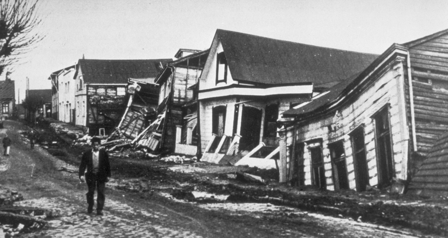
The shaking lasted approximately ten minutes. In Valdivia, the largest city in the affected zone, roughly forty percent of all buildings were destroyed. The city itself dropped in elevation: the land subsided as the plate deformed, and parts of the coast that had been dry ground became permanently inundated. Some coastal areas sank nearly two meters. They have not risen back.
| Detail | |
|---|---|
| Date | May 22, 1960, 3:11 PM local time |
| Magnitude | Mw 9.4–9.6 (largest ever recorded) |
| Rupture length | ~800 km along the Peru-Chile Trench |
| Chilean dead | ~1,655 (some estimates up to 5,700) |
| Chilean homeless | ~2,000,000 |
| Foreshock (same day) | Mw 8.1 at 6:02 AM |
The official Chilean death toll is recorded as approximately 1,655. Other estimates reach as high as 5,700, reflecting the difficulty of counting casualties in remote coastal communities where entire towns were simply gone. Two million people were left without homes. The economic damage was equivalent to roughly half of Chile's annual GDP.
Across the Pacific
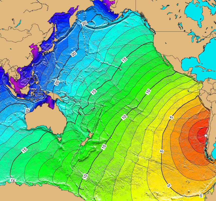
The seafloor displacement that produced the earthquake also produced a tsunami. Along the Chilean coast, waves reached twenty-five meters in some locations. But the event that makes 1960 different from other catastrophic earthquakes is what happened next, the wave kept going.
A Pacific-wide tsunami travels at the speed of a commercial jet aircraft, roughly 700 kilometers per hour in open water, because its speed is determined by ocean depth rather than wave height. In deep water the wave is barely perceptible from above, it might raise the surface by a foot or two over a crest that is hundreds of kilometers wide. You would not see it coming from a ship. Only when it reaches shallow coastal waters does the energy compress upward into something visible and lethal.
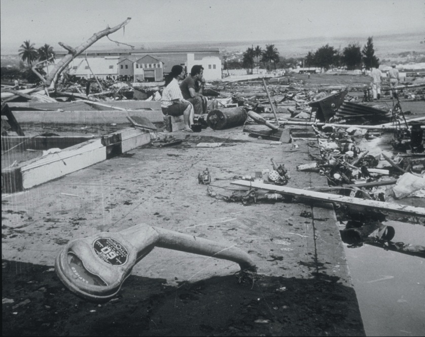
The wave crossed 10,000 kilometers of open Pacific in roughly fourteen to fifteen hours. It reached Hilo, Hawaii in the early hours of May 23rd. Hilo sits at the head of a bay that funnels and amplifies incoming wave energy. The waves that arrived measured 10.7 meters, thirty-five feet. They killed 61 people. Most of them had been warned. Most of them had evacuated. The ones who died were those who had gone back to watch, or who had not believed the sirens, or who had simply run out of time.
The wave did not stop at Hawaii.
Twenty-two hours after the earthquake, a full day after the ground had stopped moving in Chile, the tsunami reached the northeastern coast of Japan. The Sanriku coast of Tohoku, already devastated by a 1946 tsunami, was still in the process of rebuilding its warning infrastructure. The new system was not fast enough. The waves arrived before the message. One hundred and forty-two people died in Japan from an earthquake they had never felt, in a country on the other side of the world, a day after the event that generated the waves.
The Philippines recorded thirty-two dead. New Zealand and Australia reported damage. In total, the transoceanic tsunami killed more people than many earthquakes kill outright.
The Second Catastrophe
Most accounts of the 1960 earthquake stop at the tsunami. The story that is almost never told is what happened inland, in the weeks after the shaking.
The earthquake triggered massive landslides throughout the lake district east of Valdivia. Three of these landslides descended into the San Pedro River, which drains Lake Riñihue, a large glacial lake sitting in the mountains sixty-five kilometers east of the city. The landslides dammed the river completely. The lake had nowhere to drain.
Lake Riñihue began to rise.
Engineers calculated the threat quickly. Each meter the water level rose represented an additional twenty million cubic meters of volume. The dam structures created by the landslides were unstable. If the largest dam failed suddenly, which landslide dams frequently do, the resulting flood would send a wall of water down the San Pedro River and into the Valdivia River valley. Valdivia was still in ruins. The people in the valley had already survived an earthquake and a tsunami. Now they faced a potential wall of water from behind.
Approximately 100,000 people lived in the flood path.
Operation Riñihue
The engineering response, which Chileans call the Riñihuazo, was improvised, physically brutal, and ultimately one of the most successful emergency engineering operations in recorded history.
Twenty-seven bulldozers were deployed to the dam sites. The ground near the dams was saturated and unstable; the bulldozers often sank to their undercarriages in mud. Workers resorted to shovels. Military units joined engineers from ENDESA, CORFO, and the Ministry of Public Works in round-the-clock shifts. The plan was not to remove the dams, that was impossible, but to cut controlled channels through them, lowering the lake level gradually rather than allowing it to overflow catastrophically.
The operation was led by engineer Raúl Sáez. The work was done under continuous time pressure: the lake rose steadily while the channels were being cut, and any miscalculation in the channel dimensions could allow the flow to erode faster than controlled and trigger the collapse they were trying to prevent.
The lake level rose 26.5 meters before the channels began to discharge effectively. In the last week of June, more than a month after the earthquake, the water finally began to fall. The towns of Los Lagos, Antilhue, and Pishuinco were partially flooded as the controlled release sent elevated water down the valley. But the catastrophic collapse never happened. The dam held long enough to be managed.
One hundred thousand people lived downstream of a dam that no one had built and no one could remove. The engineering team had roughly six weeks to prevent a flood that would have destroyed what the earthquake had left standing.
Operation Riñihue is rarely mentioned in international accounts of the 1960 earthquake. In Chile it is remembered clearly. The country had survived the largest earthquake ever recorded, a transoceanic tsunami, and a dam crisis that threatened to deliver a third blow to the same region within two months of the first.
The Volcano
On May 24th, thirty-eight hours after the main shock, the Cordón Caulle volcanic complex erupted. The eruption was believed to have been seismically triggered, the earthquake had effectively uncorked a volcanic system that had been building pressure. The eruption produced lava flows and ash fall over a wide area. Because the region had already been evacuated for the earthquake and tsunami, deaths from the eruption were minimal. But the sequence, earthquake, tsunami, volcanic eruption, dam crisis, compressed into less than two months in the same geographic region, represents a kind of cascade that has few parallels in recorded history.
What the Earth Took
The coastal areas of southern Chile that subsided in 1960 are still lower than they were on the morning of May 22nd. The land that dropped did not rise back. In some places the sea now covers ground that was farmland or forest in 1959. Roads that ran along the coast were permanently submerged. The change is built into the geography of the region.
In Hilo, the waterfront neighborhood that was destroyed by the tsunami was rebuilt as a public park rather than residential space. The city learned from 1960 what it had not fully learned from 1946: that certain land is not safe to occupy, regardless of how many years pass between events.
In Japan, the 1960 tsunami accelerated the development of the Pacific Tsunami Warning System, which became operational in 1965. The system that failed to warn Japan in 1960, messages that arrived after the waves, was replaced by a coordinated international network. It has saved lives in every subsequent Pacific-wide tsunami event, including 2011. The 1960 warning failure is part of the reason the 2011 warning system existed at all.
The magnitude 9.5 number has not been matched since. Seismologists who study the Peru-Chile subduction zone note that the plates have been re-locking since 1960, re-accumulating the strain that produced the event. The question of when that strain releases again is not if. The 1960 earthquake did not discharge all of it.
A Note on Scale
The moment magnitude scale is logarithmic. A magnitude 9.5 earthquake releases roughly thirty-one times more energy than a magnitude 8.5, and roughly 1,000 times more energy than a magnitude 7.5. The 1960 Valdivia earthquake released more seismic energy than all other earthquakes combined in the twentieth century. That figure is not rhetorical. It is the conclusion of comparative seismic energy analyses.
The shaking lasted ten minutes. Most large earthquakes last between thirty seconds and two minutes. Ten minutes of magnitude 9.5 ground motion is not something that buildings or coastlines survive intact. The wonder of 1960 is not how much was destroyed. It is that anyone, and anything, was left standing at all.