A Quiet Afternoon on a Dangerous Seam
Good Friday, March 27, 1964, was the kind of quiet early spring afternoon that south-central Alaska does well. Snow still sat on the Chugach Mountains. Ice was breaking up in the inlets. Families were home for the holiday weekend. Anchorage was a young city of about 100,000 people, barely five years into statehood, and almost nobody living there gave much thought to what lay beneath them.
What lay beneath them was one of the most dangerous geological seams on Earth. Off the coast, the Pacific tectonic plate is sliding slowly, a few centimeters a year, down and under the North American plate. Geologists call this kind of boundary a subduction zone, and the sloping contact between the two plates a megathrust fault. For centuries the two plates had been locked together by friction, bending and straining like a stick pushed hard from both ends, storing up roughly 500 years of accumulated stress. On Good Friday, the stick snapped.
Four and a Half Minutes
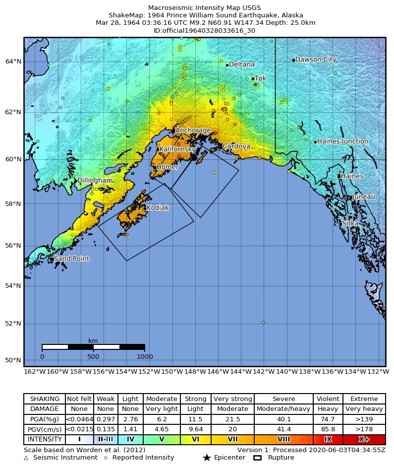
At 5:36 in the evening, Alaska time, the fault let go. The epicenter sat in northern Prince William Sound, about 78 miles east of Anchorage and roughly 15 miles deep. The rupture tore along an estimated 600 miles of the plate boundary, with the two plates lurching as much as 60 feet past one another.
The number that came out of it was a moment magnitude of 9.2. That made it the most powerful earthquake ever recorded in North America, and the second most powerful recorded anywhere on Earth since instruments began measuring in 1900, behind only the magnitude 9.5 Chile quake of 1960. What set it apart was not just the size but the length. Most damaging earthquakes are over in fifteen to thirty seconds. This one shook for four to five minutes. Survivors had time to run outside, watch their neighborhood come apart, and still be standing when it finally stopped.
Alice Arwezon of Anchorage remembered it plainly. The house rocked for about five minutes, she said, and the earth moved side to side rather than up and down. It was impossible to stand during the worst of it. Others described a low grinding roar, asphalt streets rolling like ocean swells, and the ground cracking open and slamming shut with water spouting up through the seams.
What the Ground Did
Two things made the quake so destructive. The length of the shaking was one. The other was what that shaking did to unstable, water-logged soil.
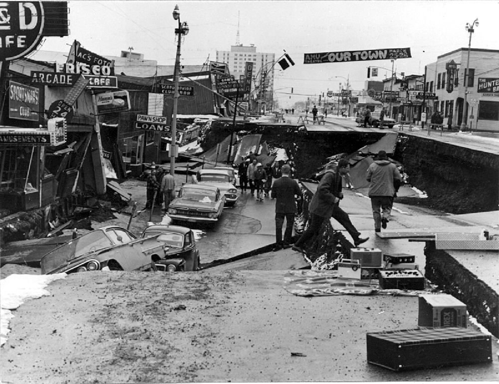
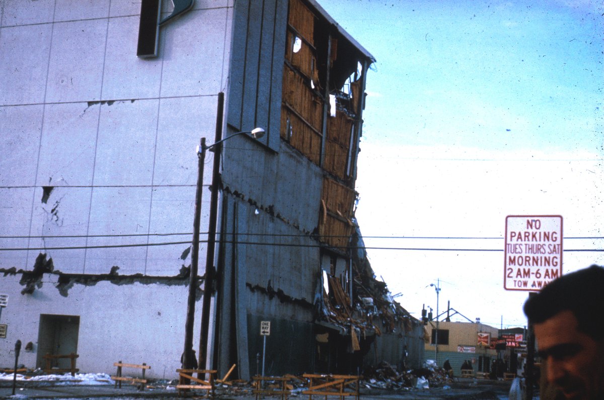
In the downtown business district, saturated clay beneath the surface liquefied and gave way. The ground itself became a fluid. A landslide dropped whole blocks of Fourth Avenue, leaving storefronts eleven feet below the street. In the down-dropped block, the sidewalk subsided about eleven feet in response to some fourteen feet of horizontal movement. A short walk away, the five-story JCPenney building had its concrete facade sheared clean off. Cars parked at its base were crushed under the falling panels.
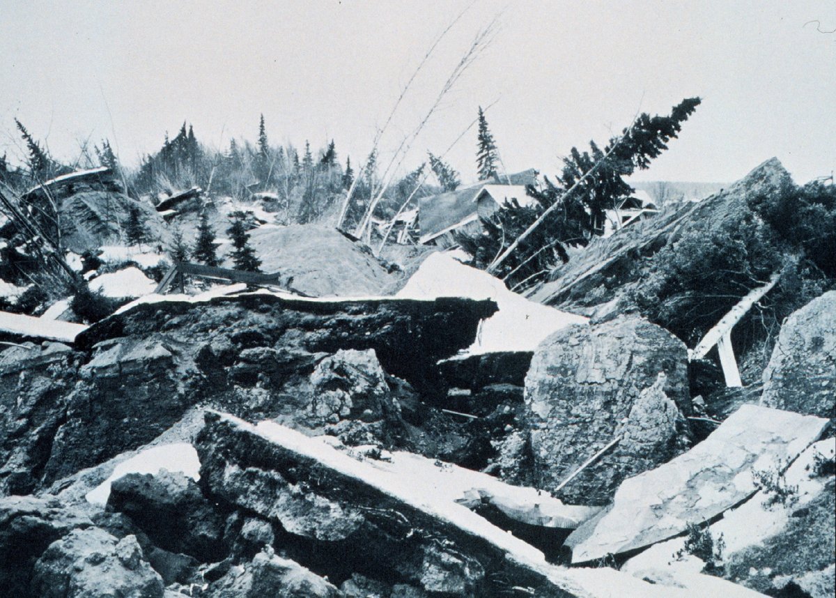
The worst of the landslides hit a bluff-top neighborhood called Turnagain Heights. About 130 acres of ground broke into tilting, sliding blocks and moved toward the water, destroying roughly 75 homes and killing several residents. It became a textbook case, studied by geologists for decades afterward. Nearby, Government Hill School was torn into two jagged, broken pieces by another slide. It was empty for the holiday. On a school day, the story would have been unbearable.
Farther out, the land itself changed elevation across roughly 100,000 square miles. Parts of Montague Island rose by about 38 feet, among the largest uplifts ever measured anywhere. Elsewhere the ground sank. Around Girdwood and Portage, near the head of Turnagain Arm, the land dropped as much as eight feet, and the sea rushed in. Portage was abandoned. Its drowned forest of salt-killed trees still stands today, a gray reminder of the day the coastline moved.
The Water Killed Most of Them
Here is the fact that surprises people most. The shaking, for all its violence, killed relatively few. The water killed nearly everyone else. Of a death toll usually given as about 131, only a dozen or fewer died from the earthquake and its landslides directly. The rest were taken by tsunamis.
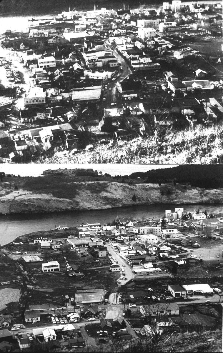
There were really two kinds of waves. The first were local tsunamis, some twenty of them, generated within minutes as the shaking dumped enormous volumes of seafloor sediment into the deep fjords. These struck before anyone could possibly be warned. At Valdez, an underwater slide collapsed the waterfront and its dock while a ship was unloading, and about 32 people on the pier were lost. The town was later rebuilt on safer ground. At Seward, waterfront landslides, waves, and burning fuel tanks combined into a single catastrophe of fire and water along the harbor.
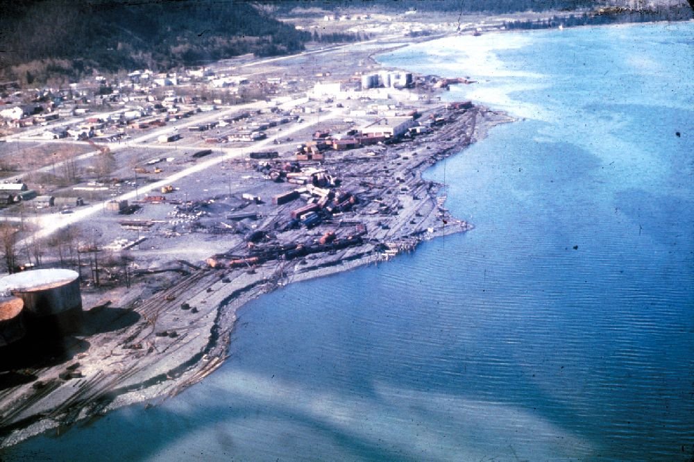
The small Native village of Chenega suffered worst of all in proportion. A wave reported near 27 feet swept through and destroyed it, killing 23 of its 68 residents. Whole families were gone in a matter of minutes.
The second kind of wave was the main tectonic tsunami, a single great pulse thrown off by the seafloor uplift itself. It radiated across the entire Pacific and was recorded in more than twenty countries, from Peru to Japan to New Zealand to Antarctica. It killed people thousands of miles from Alaska. Four children of one family, camping at Beverly Beach State Park in Oregon, were swept away. In Crescent City, California, some 1,700 miles from the epicenter, the waves arrived hours later, surged through the low downtown, wrecked about thirty blocks, and killed around eleven people. Crescent City remains the classic American example of how far a tsunami can reach to find its victims.
How a Disaster Confirmed Plate Tectonics
In 1964, the idea that continents and seafloor could move was still contested. Plenty of respected geologists doubted it entirely. The Alaska earthquake helped end that argument, and it did so in the space of five minutes.
A USGS geologist named George Plafker led the field mapping of exactly which coastlines had risen and which had sunk. The pattern he found told the story. A broad belt of uplift ran out toward the ocean trench, and a parallel belt of subsidence ran inland. That is precisely what you would expect if a gently sloping fault had thrust the ocean plate down and under the continent. Plafker concluded the quake was a megathrust rupture on a subduction zone, not a near-vertical crack. His interpretation became a keystone piece of evidence for subduction, and for plate tectonics as a whole. The Earth had run a continent-scale experiment that no laboratory could ever match.
The disaster also changed how the country prepares. The West Coast and Alaska Tsunami Warning Center, today the National Tsunami Warning Center in Palmer, Alaska, was created in 1967 as a direct answer to 1964. The quake drove decades of advances in seismology, in earthquake-resistant building codes, and in the study of the soil liquefaction that had swallowed Anchorage's streets.
What Popular Accounts Get Wrong
A few things get repeated so often they have hardened into folklore. The first is the phrase "9.2 on the Richter scale." The Richter scale saturates and cannot meaningfully measure a quake this large. The modern figure is a moment magnitude, a different calculation. The right thing to say is magnitude 9.2, not Richter.
The second is that this was the biggest earthquake in history. It was the biggest in United States and North American history, and the second biggest ever recorded, but the 1960 Chile quake was larger. The word recorded matters, because instruments only go back to about 1900. The third myth is that thousands died. For a quake this violent in a populated region, the toll was remarkably low, thanks partly to the holiday timing, the low population density, and the fact that many wood-frame Alaskan homes flexed rather than collapsed. And the last is the assumption that the shaking killed everyone. The opposite is true. The great majority died in the water, many of them in local waves that arrived within minutes.
| Measure | Value |
|---|---|
| Date & time | March 27, 1964, 5:36 p.m. Alaska time |
| Magnitude | Mw 9.2 (2nd largest ever recorded) |
| Duration | About 4 to 5 minutes of shaking |
| Rupture length | Roughly 600 miles of plate boundary |
| Deaths | About 131 (most from tsunamis) |
| Max land uplift | About 38 ft, Montague Island |
| Property damage | Roughly $116 million (1964 dollars) |
Aftermath and Legacy
Recovery came fast, and it came with the full weight of the federal government behind it. The U.S. Army quickly reopened communications to the Lower 48. The Army Corps of Engineers led a reconstruction effort estimated in the range of $110 million. A military airlift delivered more than two and a half million pounds of food and supplies to communities that had been cut off entirely.
Some of the most important work was done by a single voice. In Anchorage, a radio journalist named Genie Chance stayed on the air at station KENI for more than 24 hours without a real break. In a city with no working telephones, she relayed names, reunited families, and coordinated relief, becoming the calm center that a frightened city organized itself around. Her broadcast is now studied as a model of how information holds a community together in the hours after a catastrophe.
Total property damage came to roughly $116 million in 1964 dollars, close to a billion in today's money. Whole towns were picked up and moved. And out of that ruin came things that still protect and inform millions of people six decades later: the tsunami warning network, the seismic building codes, and the confirmed science of a moving Earth. The ground under Alaska betrayed the people who lived on it for four and a half minutes on a quiet holiday afternoon. In doing so, it taught the rest of us how the planet actually works.