A Bay Designed for Disaster
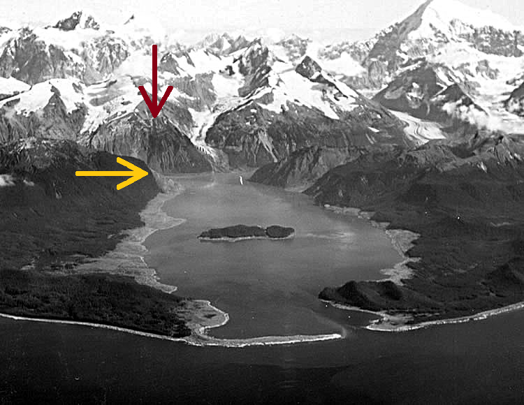
Lituya Bay sits on the Gulf of Alaska coast roughly 220 miles southeast of Fairbanks, inside what is now Glacier Bay National Park. From the air it looks like a capital T: a long, straight inlet running northeast from the Gulf, intersected near its head by two shorter arms. The whole thing is about nine miles long and two miles across at its widest point. The walls rise several thousand feet on either side.
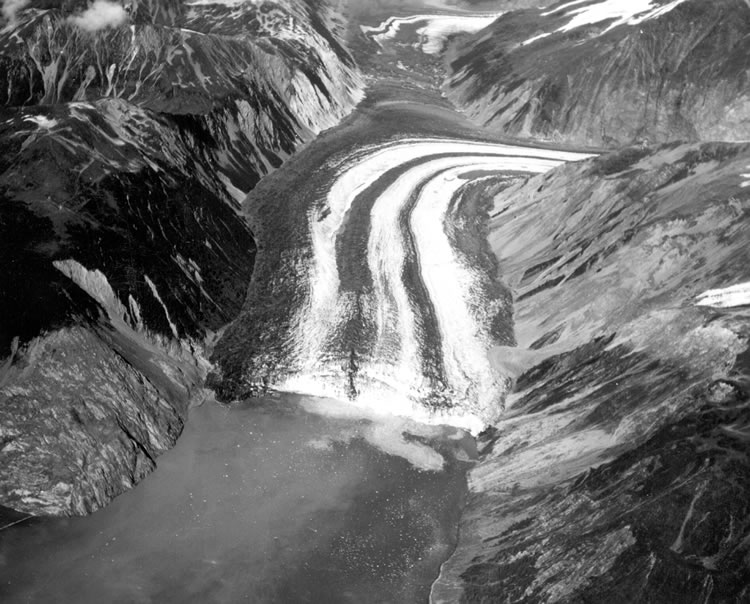
The bay owes its shape to the Fairweather Fault — a right-lateral strike-slip fault analogous in character to California's San Andreas, where the Pacific Plate grinds northwest against the North American Plate. Over millions of years, glaciers exploited the weakened, shattered rock along the fault line, carving the linear trough that became the bay. At the northeastern end, where the fault cuts most directly through the inlet, the walls are steep, heavily fractured, and loaded with ice from Lituya and North Crillon Glaciers. At the other end, near the Gulf, the bay's mouth is barely a thousand feet wide and thirty-three feet deep — an almost-sealed exit that traps whatever energy builds inside.
USGS geologist Don Miller had been studying Lituya Bay since 1952. He found trimlines — sharp boundaries where all vegetation had been scoured off the walls — at multiple elevations above the water. By reading tree rings and comparing the trimlines to historical records, he reconstructed a disturbing pattern: a giant wave had struck the bay in 1853, again around 1874, again in 1899, and again in October 1936. The 1936 wave had reached 490 feet. None of them had been caused by tectonic tsunamis. All of them were generated by mass wasting events — rockslides, ice avalanches, submarine slides — falling into the confined water at the bay's head. Miller estimated a megatsunami hit Lituya Bay roughly once every twenty to thirty years. He published his findings in 1953. Nobody paid much attention.
10:15 PM, July 9, 1958
The earthquake struck at 10:15 PM Alaska Standard Time. It registered Mw 7.8 — a moment magnitude assigned by modern re-analysis; early instruments had estimated 8.3, which overstated the energy of large strike-slip events. The rupture extended roughly 125 miles along the Fairweather Fault, from Palma Bay to Icy Bay. Ground motion was felt from Seattle to Whitehorse. The most violent shaking lasted about forty seconds.
The fault displacement was significant and measurable: approximately 21 feet of horizontal movement, with the southwest side of the bay shifting northwest relative to the northeast side, and roughly 3.5 feet of vertical uplift. At the epicenter — about thirteen miles southeast of the head of Lituya Bay — the ground was moving fast enough and hard enough to shake loose whatever had been waiting to fall.
What had been waiting was the northeast wall of Gilbert Inlet.
The Mountain Falls
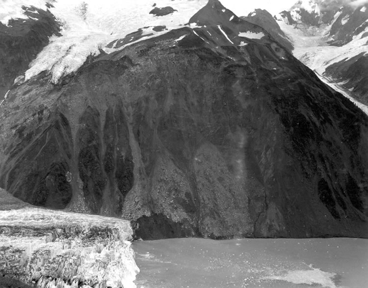
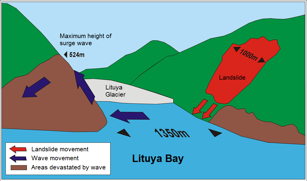
The rockslide released from a point on the northeast wall of Gilbert Inlet, the northernmost arm of the bay, where the Fairweather Fault intersects the inlet wall directly. Approximately 40 million cubic yards of rock — somewhere between 75 and 90 million tons of it — separated from the cliff face and dropped. Don Miller described it as falling "practically as a monolithic unit" at close to vertical. The center of gravity was at roughly 2,000 feet above sea level. The rock struck the water at the head of the inlet essentially instantaneously.
Bill Swanson, anchored two miles away, watched it happen. He later described it: "The glacier had risen in the air and moved forward... Big chunks of ice were falling off... like a big load of rocks spilling out of a dump truck." What Swanson saw as the glacier "rising" was actually the shockwave of the impact — the force of 40 million cubic yards striking the water had broken off and uplifted 1,300 feet of Lituya Glacier's terminal face, momentarily heaving it skyward before it collapsed back.
The sound of impact was heard 80 kilometers away.
The Wave
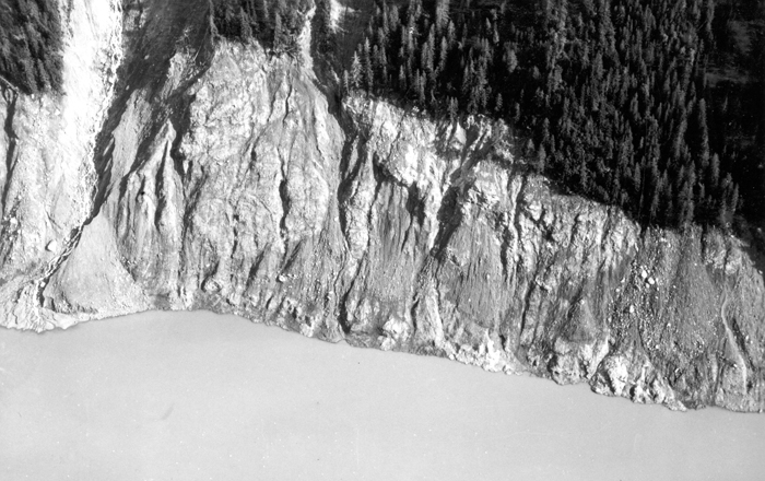
The rockslide struck the water with so much energy, so quickly, that it didn't simply generate a wave — it displaced the entire water column of Gilbert Inlet in a single catastrophic impact. The initial event is more accurately described as a splash than a wave: the displaced water surged up the southwest wall of the inlet and climbed to a height of 1,720 feet (524 meters) above sea level, shearing every tree and stripping the soil to bare rock. That measurement — 1,720 feet — is the runup height on the opposing slope, not the height of a free-standing wave.
The wave that then rolled down the main body of the bay was considerably smaller but still extraordinary: approximately 100 feet at the bay head, estimated at 50 to 75 feet as it reached the anchored boats roughly 2.5 miles away. It traveled at between 100 and 130 miles per hour through the main channel. It reached the three fishing boats in under three minutes.
Scientists have argued about terminology ever since. Don Miller called it a "giant wave" in his 1960 USGS report. Fluid dynamicists call it an "impulse wave." The broader scientific community eventually settled on "megatsunami" — a catch-all for waves generated by mass wasting events, as opposed to the tectonic seafloor displacement that produces conventional tsunamis. Whatever you call it, it was the largest wave runup ever measured in recorded history, and it remains so today.
| Year | Max Runup | Cause |
|---|---|---|
| 1853–54 | 395 ft (120 m) | Rockslide, south wall near Mudslide Creek |
| ~1874 | ~80 ft (24 m) | Possible slide, Crillon Inlet area |
| 1899 | ~200 ft (60 m) | Slide or fault displacement, Crillon Inlet |
| Oct. 27, 1936 | 490 ft (150 m) | Crillon Inlet; tidal glacier or submarine slide |
| Jul. 9, 1958 | 1,720 ft (524 m) | Rockslide, northeast wall of Gilbert Inlet |
The Three Boats
At 10:15 PM on July 9, 1958, three fishing vessels were anchored inside Lituya Bay. The earthquake and what followed killed two people and produced two of the most detailed eyewitness accounts of a megatsunami ever recorded.
Howard Ulrich and his son Sonny were aboard the Edrie, anchored in a cove on the southeastern shore of the main bay. Sonny, seven years old, was already asleep. When the earthquake woke them both, Ulrich went on deck and watched what he described as an "ice cloud" rise over Gilbert Inlet, followed by what he first took for a 50-foot wave. He grabbed the radio: "Mayday, Mayday. This is the Edrie in Lituya Bay. All hell has busted loose in here. I think we've had it." He tossed Sonny a life jacket, told him to start praying, and tried to raise anchor. The windlass jammed. He paid out all 210 feet of chain.
The wave snapped the chain "like a string" and carried the Edrie shoreward. At its crest, Ulrich could look down and see the treetops below him. Then the wave pulled back and deposited the boat into the churning main bay. Both Ulrich and Sonny were uninjured. The Edrie motored out through the debris-choked entrance around 11 PM. Ulrich said afterward: "I was sure that the end of the world had come for Sonny and me."
Bill and Vivian Swanson were aboard the Badger, anchored inside La Chaussee Spit near the bay's mouth — about two miles from the rockslide source. Bill was on deck collecting chunks of glacial ice when the earthquake hit. He watched the wave from two miles away, then felt it take his boat. The Badger was seized stern-first and carried over La Chaussee Spit, surfing below the crest of the wave. At the top, Swanson was looking down at trees — the boat was an estimated 80 feet above the spit. He could see the open ocean on the other side.
The Badger came down hard beyond the spit and began sinking. A log punched through the cabin, breaking four of Bill's ribs. The Swansons abandoned the boat and spent the next two hours adrift in an 8-foot skiff, using a chair as a paddle, before a rescue vessel found them by spotlight around midnight. Vivian Swanson never went out on a boat again. Bill made a full physical recovery, returned to Lituya Bay in May 1962 — and died of a heart attack upon arrival.
"We were looking down on the trees and I could see their tops... I know this is hard to believe, but this is what happened."
— Bill Swanson, survivor
Orville and Mickey Wagner were aboard the Sunmore, also anchored near the bay's mouth. The last anyone saw them, they were waving across the water to the Swansons. The working theory, inferred from their position, is that they attempted to run for the entrance when the earthquake struck — the worst possible decision. Nothing was recovered. No bodies were found. No wreckage was positively identified. The Sunmore and the Wagners disappeared entirely.
What the Wave Did to the Forest
Below the trimline, the destruction was absolute. Trees up to four feet in diameter were sheared at their bases, their bark stripped, their branches removed. They all lay pointing westward — the direction the wave traveled down the bay. Mountaineers' camps were scoured to bare bedrock. The lighthouse at Harbor Point was obliterated. Floating debris — tree trunks and glacial ice — extended five miles into the Gulf of Alaska after the event.
Above the trimline, the forest was untouched. The precision of the boundary allowed Don Miller to measure the wave's maximum height not as an estimate but as a direct measurement. He arrived by floatplane the morning of July 10th, roughly twelve hours after the event, and spent weeks documenting what he found. His 1960 USGS Professional Paper 354-C remains the primary scientific record of the event. When his findings were published, the runup measurement of 1,720 feet was "widely doubted both on theoretical grounds and on the basis of aerial observations," according to the Alaska Earthquake Center. The scientific community had no framework for a wave of that scale generated by a landslide.
Miller already did. He had documented four previous waves in this same bay. Lituya Bay 1958 didn't surprise him — it exceeded his worst projections by a factor of more than three and forced the rest of the scientific community to catch up.
Scientific Legacy
Before Lituya Bay 1958, the concept of a "megatsunami" barely existed in scientific literature. Landslide-generated waves were considered curiosities, not systematic hazards. The prevailing assumption was that tsunamis required tectonic seafloor displacement on a massive scale to produce anything catastrophic.
Miller's documentation overturned that assumption. R.L. Wiegel built a 1:1,000 scale physical model of the bay in the 1960s and confirmed the landslide mechanism. Hermann Fritz and Willi Hager at ETH Zurich replicated it more precisely in 2001 with a pneumatic landslide generator. Los Alamos National Laboratory ran full Navier-Stokes numerical simulations. A 2010 analysis by Ward and Day proposed that the initial rockslide triggered a secondary release of subglacial sediment from beneath Lituya Glacier — five to ten times the volume of the original slide — which would explain why the wave contained more energy than the 40 million cubic yard rockslide alone could account for.
The Alaska Earthquake Center's summary is direct: "This is the largest and most significant megatsunami in modern times; it forced a re-evaluation of large-wave events and the recognition of impact events, rockfalls, and landslides as causes of very large waves."
The Bay Today
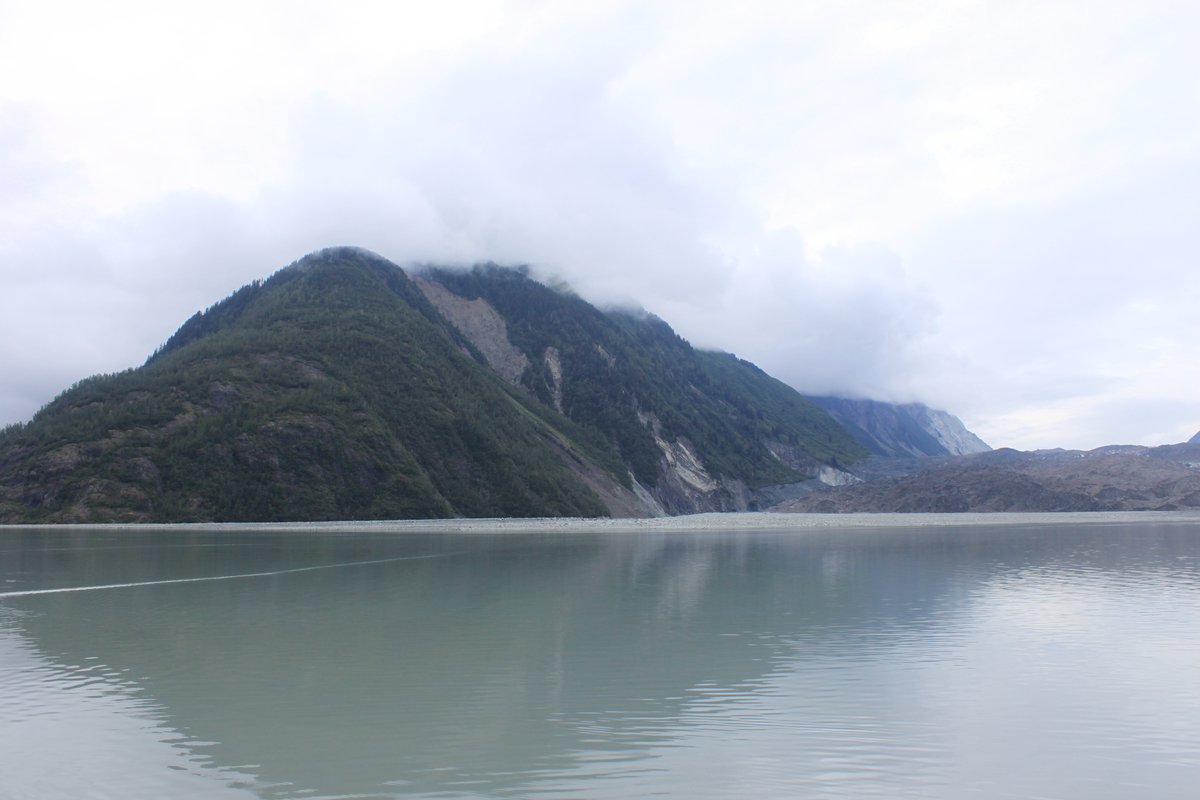
The trimline is still visible. Visitors approaching the head of the bay by boat report seeing the demarcation line climbing the slopes to over 1,700 feet — the divide between old-growth forest and the younger alder and spruce that has regrown since 1958. The boundary is still sharp enough to see from the water with the naked eye, 67 years later.
In August 2025, NOAA Ship Rainier conducted the bay's first comprehensive bathymetric survey since 1959, mapping 15.5 square miles of seafloor with multibeam sonar over five days. The findings were striking. Pre-survey charts showed depths up to 129 meters at the bay's head. The survey found the same area was essentially walkable land — over 130 meters of sediment had infilled since 1959. Chief Hydrographic Survey Technician Jim Jacobson: "The entire head of the Bay had filled in — on the chart, it showed depths of up to 129 meters, but in reality, it was walkable land." The infill is ongoing, fed by glacial retreat, sediment transport, and continued small rockslides from the same walls that collapsed in 1958.
The Fairweather Fault is still active. The geological record suggests a megatsunami every twenty to thirty years. As of 2026, sixty-eight years have passed since the last one. Fishing boats still enter the bay at slack tide — the only window when the twelve-knot current at the mouth is survivable. The National Park Service includes hazard notices in its literature. Don Miller's estimate of a 1-in-9,000 daily probability has not changed.
The bay that took the Wagners and turned Vivian Swanson's hair gray is still there, still beautiful, still dangerous. The rock that fell in 1958 is sitting at the bottom of Gilbert Inlet. The trimline on the southwest wall is bare to 1,720 feet. The next slide is somewhere on the northeast wall, waiting.
A Note on La Pérouse
The 1958 wave was not the bay's first mass casualty event. On July 13, 1786, French explorer Jean-François de Galaup, Comte de La Pérouse, dispatched three small boats to map the bay's entrance depths. The tidal current — which reaches twelve knots through the thousand-foot-wide mouth — pulled two of them into the breaking surf. Both boats were swamped. All 21 men drowned; no bodies were recovered. La Pérouse named the island at the center of the bay Cenotaph Island — a cenotaph being a memorial for those buried elsewhere.
The Tlingit people who had used the bay for centuries already knew the entrance was lethal and entered only at slack tide. They had a traditional explanation for the bay's dangers: a supernatural being called Kah Lituya, who lived in an underwater cave and resented intrusion, causing catastrophic waves when disturbed. Given what the geological record shows — a megatsunami roughly every generation for as far back as the evidence extends — this is less superstition than accurate local knowledge.