The mountain had a name that told you everything. In the local Friulian dialect, Toc means rotten. The people of the valley called it Monte Toc: the crumbling mountain, the mountain that moved beneath your feet, the mountain whose rock broke apart when you touched it. They reported the moving ground to the engineers who came to build a dam below it. They testified in court on behalf of a journalist prosecuted for writing about it.
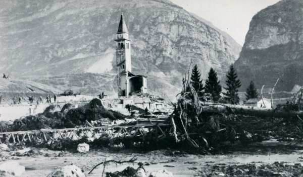
On the night of October 9, 1963, 260 million cubic metres of Monte Toc slid into the Vajont reservoir. The wave that resulted was 820 feet tall. It went over the dam and destroyed the town of Longarone in four minutes. Nearly 2,000 people died.
The dam is still standing.
A Canyon in the Dolomites
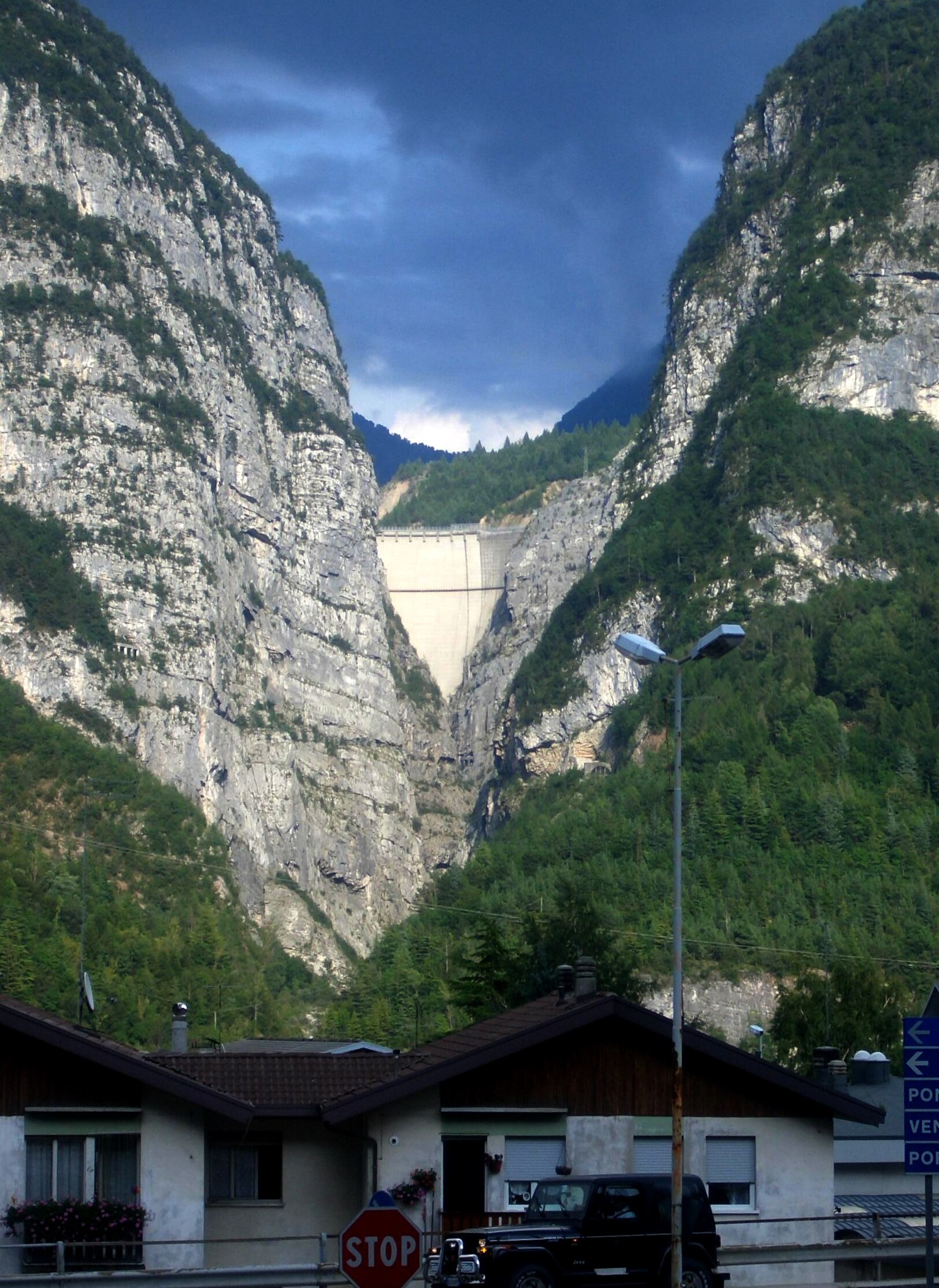
The Vajont gorge cuts through the Dolomite Alps roughly a hundred kilometres north of Venice. The river carved a narrow limestone canyon with near-vertical walls, hemmed on the south by Monte Toc, funnelling directly down into the Piave River valley where the town of Longarone sat on flat ground below.
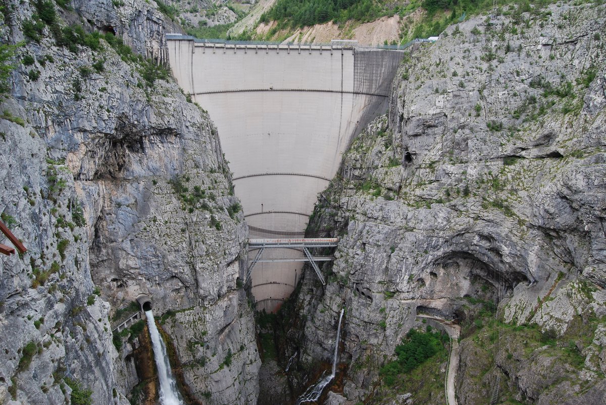
The dam was conceived in the 1920s by engineer Carlo Semenza, who saw the gorge as an ideal site for hydroelectric power. Construction ran from 1957 to 1959. When complete, the Vajont Dam stood 262 metres (860 feet), among the tallest dams ever built. It was a double-curvature arch dam: extraordinarily thin, with a crest only 3.4 metres wide, transmitting water pressure into the canyon walls via arch action rather than resisting it through sheer mass. An engineering achievement of the first order.
The builder was SADE, the Società Adriatica di Elettricità, the electricity monopoly of northeastern Italy. By the time of the disaster, SADE had been nationalised and operations transferred to ENEL. It made no practical difference. The decisions had already been made.
The Geology SADE Did Not Want to Hear
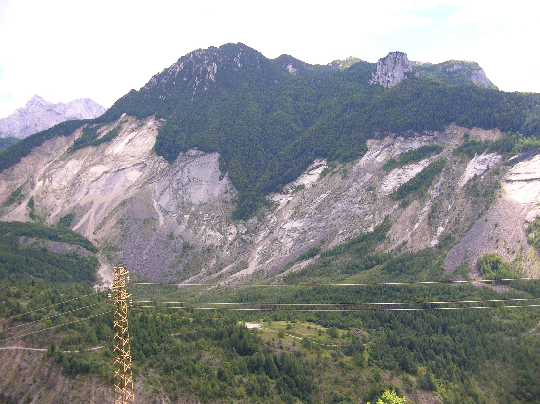
In the late 1950s, Eduardo Semenza, son of the dam's designer and a geologist himself, studied the slopes above the proposed reservoir. He concluded that the hillside on Monte Toc's northern face was not solid rock. It was ancient landslide debris: the remnants of a prehistoric collapse that had solidified in place over centuries. A new slide, he determined, could reactivate along the same buried failure surface. He submitted maps, photographs, and geological findings to SADE. They were dismissed.
As the reservoir filled in 1960, a fracture appeared across the mountain's face. More than two kilometres long, it defined the outline of a potential slide mass roughly 1,700 metres wide. The mountain began to move.
On November 4, 1960, approximately 700,000 cubic metres of the slope collapsed into the reservoir, creating a two-metre wave. SADE halted filling and lowered the water level by fifty metres. This was understood not as a warning that something far larger was coming, but as proof that the slide could be managed. The logic: raise the water slowly, lower it if movement accelerates. The mountain, the engineers believed, could be controlled like a dial.
In February 1961, Leopold Müller arrived. He was an Austrian engineer, one of the world's foremost experts in rock mechanics. After inspecting the site and reviewing the data, he wrote to SADE that the risk of catastrophic failure was real and that preventing it lay, in his own words, "beyond human bounds." He recommended abandoning the project entirely.
SADE did not abandon the project.
A journalist named Tina Merlin had published a report in 1959 about the landslide danger above Erto. SADE charged her with spreading "false and tendentious news likely to disturb public order." The people of Erto testified on her behalf. She was acquitted on November 30, 1960. Four days later, the first major collapse occurred.
By summer 1963, the creep had resumed and was accelerating sharply. On September 15, the south face of Monte Toc shifted 22 centimetres in a single day. By early October, daily movement reached approximately one metre. Monitoring continued. The reservoir remained at 710 metres: ten metres above the level that hydraulic model tests had suggested was the safe limit.
The Numbers
Dam height: 262 metres (860 feet)
Landslide volume: 260 million cubic metres — 400 times larger than the 1960 collapse
Landslide speed: 110 km/h (68 mph), reaching the water in under 45 seconds
Wave height above reservoir: 250 metres (820 feet)
Water overtopping the dam: approximately 50 million cubic metres in 25 seconds
Time for wave to reach Longarone: 4 minutes
Official death toll: 1,917 — Longarone fatality rate: 94 percent
Twenty-Five Seconds
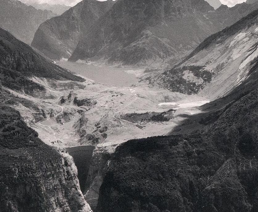
At 10:39 PM on October 9, 1963, the north face of Monte Toc detached. The entire mass, 260 million cubic metres of rock, forest, and earth, slid northward into the reservoir at 110 kilometres per hour. The whole movement lasted less than 45 seconds.
The slide was roughly 400 times larger than the 1960 collapse that engineers had treated as a managed event.
The displaced reservoir climbed 250 metres above its normal level on the opposite canyon wall: higher than the dam itself. The wave split. One portion moved east toward Erto and Casso. The larger portion crested the dam in a wall of water between 100 and 330 metres high and fell into the Piave Valley below. Approximately 50 million cubic metres of water overtopped the dam in roughly 25 seconds.
Four Minutes
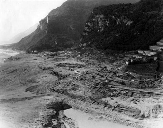
Longarone was three kilometres downstream. The wave reached it at 10:43 PM.
Most people in the town were asleep. There was no warning that could have reached them in time. The air pressure wave arrived before the water itself, stripping clothes from bodies, tearing buildings apart. Survivors described a roaring wind in the seconds before the flood hit.
Of approximately 1,328 people in Longarone that night, 1,269 died. A fatality rate of 94 percent. The town was not damaged. It ceased to exist.
The villages of Pirago, Rivalta, Villanova, and Faè were also destroyed. Erto and Casso, struck by the eastward wave and the air blast, lost more than 150 additional people. The official death toll was 1,917. Some estimates run as high as 2,500. Approximately 350 families lost every single member.
"It was genocide." — Tina Merlin, l'Unità, October 11, 1963
One ENEL engineer, earlier that evening, had reportedly told a colleague there might be "a little water over the dam tonight — nothing to be alarmed about."
The Dam Is Still Standing
The Vajont Dam survived. The arch design transfers hydraulic load into the canyon walls rather than resisting it through mass. It held against forces many times its design parameters. Only approximately one metre of masonry at the crest was scoured away. Two-thirds of the reservoir's water remained impounded behind the intact structure.
Today the dam is owned by ENEL. The reservoir it was built to fill no longer exists. The landslide debris filled the valley to more than half the dam's height. What was a mountain lake is now overgrown pasture and sparse forest. A pumping station maintains a small remnant lake a few kilometres upstream.
From the village of Casso, on the slope above the former reservoir, the whole disaster is visible in a single view: the dam, the filled valley, and the M-shaped scar on the flank of Monte Toc where 260 million cubic metres of rock detached. That scar has not healed. It is still clearly visible more than sixty years later.
A metal walkway crosses the dam crest. Standing on it, you look down 262 metres to the canyon floor, and out across what is no longer a reservoir. Guided tours run for approximately 45 minutes. The entry fee is around five euros.
Two Years
Criminal proceedings opened in 1968. Eleven men were charged. The trial was moved to L'Aquila in Abruzzo, far from the disaster site, limiting survivor participation. Mario Pancini, one of SADE's chief engineers, committed suicide before the trial concluded.
Italy's Court of Cassation, on final appeal in March 1971, identified two men as primarily responsible. Alberico Biadene, director of SADE's hydraulic construction service, was sentenced to five years. Three years were pardoned under amnesty. He served approximately two years.
Giovanni Leone, who would later become President of Italy, served as a central figure in SADE's legal defence. At least 600 victims received no compensation at all.
The trial documents, 250 folders of legal acts, seismic recordings, rock samples, and photographs, are registered in UNESCO's Memory of the World Programme as an exemplary record of engineering accountability failure. They are studied in geology, engineering, and legal programmes around the world.
Tina Merlin, prosecuted for reporting the danger four years before it happened, later published a book: Sulla pelle viva, "On Living Skin: How a Catastrophe Is Constructed." She died in 1991.
The dam is still standing.
Works Cited
- Vajont Dam — Wikipedia
- Vajont Dam, Italy, 1963 — Association of State Dam Safety Officials
- Vaiont Dam — Encyclopaedia Britannica
- Benchmarks: October 9, 1963 — Earth Magazine
- The Vaiont Landslide of 1963 — AGU Landslide Blog
- Expecting Disaster: The 1963 Landslide at Vajont Dam — Environment and Society Portal
- Remembering the Vajont Dam Disaster, 60 Years Later — U.S. Army
- Criminal Proceedings of the Vajont Dam Disaster — UNESCO Memory of the World
- The Vajont Dam — We Build Value
- Tina Merlin and the Vajont Disaster — Tirelli and Partners
- October 9, 1963: Vajont — Scientific American