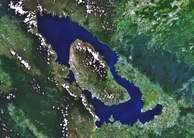
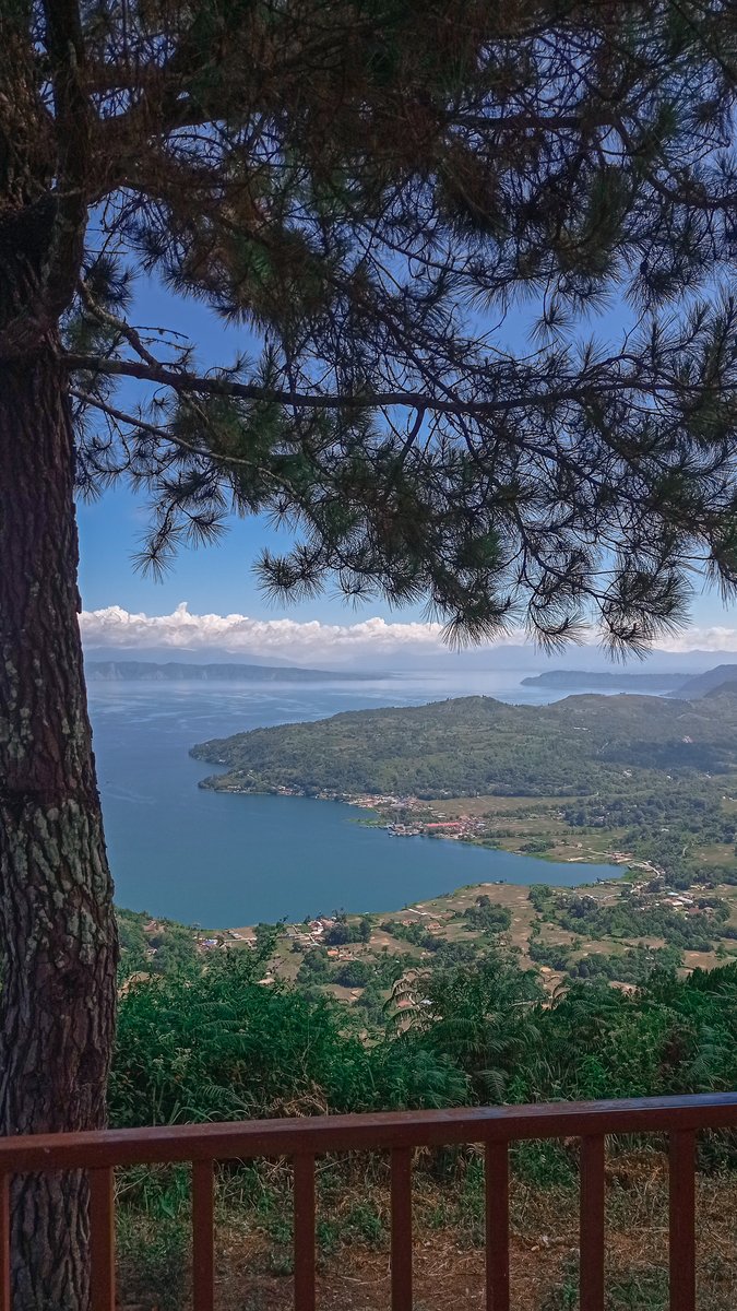
Lake Toba sits in the highlands of North Sumatra, Indonesia. It is 100 kilometres long, 30 kilometres wide, and 505 metres deep — the largest volcanic lake on Earth. The mountains surrounding it are not mountains in the ordinary sense. They are the rim of a caldera: the collapsed depression left when a volcanic system evacuated so much material so quickly that the ground above it fell into the void.
At the centre of the lake, rising more than 450 metres above the waterline, is an island called Samosir. It is not natural topography. It is a resurgent dome — a mass of rock pushed upward by magma pressure accumulating beneath the emptied chamber, still rising today at roughly one centimetre per year. The volcano is not finished.
The Eruption
The Toba system has erupted catastrophically at least four times in the past 1.4 million years. The most recent and most violent of these — the Youngest Toba Tuff event, dated by argon isotope analysis to approximately 73,880 ± 320 years ago — was not simply the largest eruption in human memory. It was the largest eruption in the Holocene epoch, and possibly in the last two million years of geological history.
The eruption ranks as a Volcanic Explosivity Index 8 — the maximum category. Every other number on that logarithmic scale represents a tenfold decrease in intensity. Mount St. Helens in 1980 was a VEI 5. Krakatoa in 1883, which killed 36,000 people, was a VEI 6. Tambora in 1815, the largest eruption in recorded history, was a VEI 7. Toba was a VEI 8 — roughly 10,000 times the scale of Mount St. Helens.
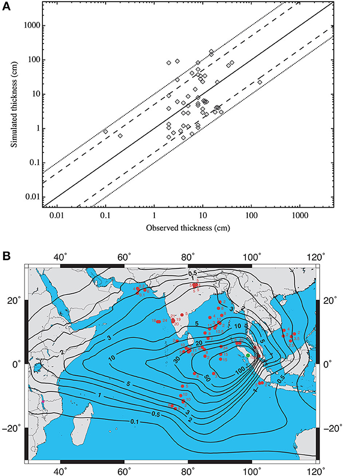
The volume of material ejected has been revised upward repeatedly as geologists map the deposits more completely. The most comprehensive modern analysis, published in Frontiers in Earth Science in 2014, estimates the total at approximately 5,300 cubic kilometres of dense-rock equivalent material — including the ash that fell across the Indian Ocean and South Asia, and the pyroclastic flows that incinerated 20,000 square kilometres of landscape around the caldera. In bulk volume, the figure exceeds 13,000 cubic kilometres. To put that in terms that make physical sense: the entire eruption of Krakatoa produced approximately 21 cubic kilometres of material. Toba produced more than 600 times as much.
The eruption column rose approximately 42 kilometres into the atmosphere — into the stratosphere and above the ozone layer. Sulfur dioxide released at that altitude does not rain out within weeks, as tropospheric volcanic emissions do. It stays. Combined with water vapour, it forms sulfuric acid aerosols that spread around the planet on stratospheric winds and persist for years, forming a reflective veil that redirects incoming solar radiation back into space before it can warm the surface below.
Toba at a Glance
Date: ~73,880 ± 320 years ago
Location: North Sumatra, Indonesia
VEI: 8 (maximum category; highest in at least 2 million years)
Material ejected: ~5,300 km³ dense-rock equivalent; ~13,000+ km³ bulk
Ash coverage: blanket over South Asia extending 40 million km²
Caldera formed: 100 × 30 km; Lake Toba now fills it
Proposed human population bottleneck: 10,000–15,000 individuals
The Ash That Fell Across a Continent
The Youngest Toba Tuff ash layer has been identified in sediment cores and geological outcrops across an enormous area. In Malaysia, 350 kilometres from the caldera, ash deposits average 90 centimetres and reach 3 metres in some locations. In India, 3,000 kilometres away, the layer runs from 50 centimetres to more than a metre in river valleys, reaching 6 metres in places where topography concentrated falling material. The layer appears in marine sediment cores from the Arabian Sea, the Bay of Bengal, and the South China Sea. The eruption's microscopic glass particles — cryptotephra — have been found in Greenland ice cores and Antarctic ice, confirming that the aerosols reached both poles.
A separate effect operated simultaneously. As the stratospheric aerosol veil formed and thickened, it also absorbed ultraviolet radiation, depleting stratospheric ozone. A 2021 study published in Communications Earth and Environment modeled this UV catastrophe and concluded that tropical ozone depletion may have reached 50 percent for more than a year — a level that would have dramatically increased UV-B radiation reaching the surface, damaging plants and the DNA of organisms exposed to sunlight.
The Volcanic Winter
Climate modeling of the Toba event presents a range of scenarios depending on the assumed sulfur dioxide emission. The best modern estimates, derived from bipolar ice core records, suggest stratospheric sulfate loading at approximately 535 teragrams — roughly six times the loading from Tambora, which caused the 1816 Year Without a Summer, and twenty times the loading from Pinatubo in 1991. At that scale, climate models project global average cooling of several degrees Celsius, with the most severe impacts concentrated in Asia, North America, and Europe, where growing seasons would have been eliminated for years.
The older popular characterization — six years of total darkness — is an overstatement derived from high-sulfur-emission model scenarios. The most recent ice core analysis and paleoclimate reconstructions suggest pronounced cooling lasting two to five years, followed by gradual recovery. That is still long enough to eliminate most food sources for any population dependent on wild plants and game. For a species already numerically small, living at the edge of ecological margins as all hunter-gatherer populations do, even a two-year disruption of food chains could be existentially catastrophic.
The Question of Human Survival
In 1998, anthropologist Stanley H. Ambrose of the University of Illinois published a paper in the Journal of Human Evolution that connected Toba to a striking feature of human genetics. All modern humans show unusually low genetic diversity compared to other great apes. Chimpanzees in a single African forest show more genetic variation than the entire global human population. Ambrose proposed a mechanism: the Toba eruption had triggered a population crash so severe that our species passed through a genetic bottleneck, with as few as 10,000 to 15,000 individuals surviving worldwide. The limited genetic diversity in all living humans would be the demographic inheritance of those few survivors.
The hypothesis was compelling and widely cited. It has also been substantially challenged by subsequent research.
The most direct challenge came from archaeology. In 2007, Michael Petraglia and colleagues published a study in Science examining stone tool assemblages at Jwalapuram in the Jurreru River Valley of southern India, a site directly under the Toba ash layer. They found tool assemblages of similar character both below and above the ash — before and after the eruption. The populations making those tools had continued, apparently without dramatic interruption, through one of the largest volcanic events in human prehistory.
Subsequent work extended this finding. A 2020 study at Dhaba in the Middle Son River Valley found the same lithic technology spanning 80,000 to 65,000 years ago, bracketing the Toba event without discontinuity. At Pinnacle Point on the South African coast, cryptotephra chemically matched to Toba has been identified in layers showing continuous human occupation, with evidence suggesting human activity at the site actually increased in the period following the eruption. At Shinfa-Metema in Ethiopia, occupation continued through the event horizon.
The genetic counter-evidence is equally significant. Multiple genome-wide analyses have failed to detect a population bottleneck specifically at 74,000 years ago. The narrow genetic diversity of modern humans, now understood more precisely through ancient DNA analysis, is better explained by the Out of Africa founder effect — the exponentially small founding population that left Africa approximately 50,000–60,000 years ago and ultimately populated the rest of the world.
The debate is not resolved. The geological reality of Toba's environmental impact is not in dispute — the eruption was real, the ash fell, the aerosols loaded the stratosphere. What remains contested is how severely, and whether that severity reached the threshold required to collapse a species numerically.
Samosir Island and the Living Volcano
The resurgent dome at the centre of Lake Toba is among the largest of its kind on Earth. Since approximately 33,700 years ago — roughly 40,000 years after the eruption — the caldera floor has been rising as magma accumulates in a shallow reservoir 3.5 to 5 kilometres below the surface. The cumulative uplift on the eastern portion of Samosir has been modeled at approximately 700 metres over that period, with the uplift rate highest in the early post-eruption millennia and slowing to approximately 0.7 centimetres per year in modern times.
The modern uplift rate at Toba is far below the rates seen at actively restless calderas like Campi Flegrei in Italy or Yellowstone in Wyoming, where episodes of ground inflation can reach tens of centimetres per year. Toba's current behavior is consistent with slow post-eruption recharge — not the precursor signature of an imminent eruption. Researchers who have modeled the magma accumulation rate estimate that the conditions required for another VEI 8 event are approximately 600,000 years away.
The smaller point is not comforting, exactly. Another Toba-scale event would not require a rerun of the full catastrophe to be devastating. A VEI 7 event from the same system — the scale of Tambora — would be capable of regional devastation and global climate disruption at the level that caused the 1816 famine and the writing of Frankenstein. At VEI 7, it would be the largest eruption in recorded history.
The 2021 modeling study by Benjamin Black and colleagues in PNAS attempted to reconstruct where human populations would have been most sheltered from a Toba-scale event. Their finding: sub-Saharan Africa, and particularly coastal and riverine sites in Africa, would have experienced the most muted cooling — near-zero probability of summer temperatures exceeding 4°C below normal even under the highest sulfur estimates. Asia and North America would have borne the worst impacts. The African coast, with its shellfish and aquatic resources buffered from atmospheric disruption, may have been the geological circumstance that saved us.
The people who survived Toba — wherever they were, however many of them there were — left no record. They left only their genes. Every human alive today carries the inherited consequence of whatever they endured, embedded in the narrow band of our shared genetic variation, waiting for molecular biologists to read it like a scar.
Works Cited
- Ambrose, S.H. (1998). Late Pleistocene human population bottlenecks, volcanic winter, and differentiation of modern humans. Journal of Human Evolution 34(6), 623–651. PubMed
- Rampino, M.R. & Self, S. (1992). Volcanic winter and accelerated glaciation following the Toba super-eruption. Nature 359, 50–52. Nature
- Petraglia, M. et al. (2007). Middle Paleolithic assemblages from the Indian subcontinent before and after the Toba super-eruption. Science 317, 114–116. Science
- Chesner, C.A. (2014). The magnitude and impact of the Youngest Toba Tuff super-eruption. Frontiers in Earth Science 2:16. Full text
- Black, B.A. et al. (2021). Global climate disruption and regional climate shelters after the Toba supereruption. PNAS 118(28):e2013046118. PNAS
- Osipov, S. et al. (2021). The Toba supervolcano eruption caused severe tropical stratospheric ozone depletion. Communications Earth & Environment 2:71. Nature
- Costa, A. et al. (2021). New insights into the ~74 ka Toba eruption from sulfur isotopes of polar ice cores. Climate of the Past 17, 2119–2137. Full text
- Gathorne-Hardy, F.J. & Harcourt-Smith, W.E.H. (2003). The super-eruption of Toba, did it cause a human bottleneck? Journal of Human Evolution 45(3), 227–230. PubMed
- Clarkson, C. et al. (2020). Human occupation of northern India spans the Toba super-eruption ~74,000 years ago. Nature Communications. Nature
- Baines, P.G. et al. (2015). Resurgent Toba — field, chronologic, and model constraints on time scales and mechanisms of resurgence at large calderas. Frontiers in Earth Science 3:25. Full text
- Smithsonian Institution Global Volcanism Program. Toba (volcano number 261090). GVP
- Chesner, C.A. et al. (1991). Eruptive history of Earth's largest Quaternary caldera (Toba, Indonesia) clarified. Geology 19(3), 200. GeoScienceWorld