The Lake Behind the Ice
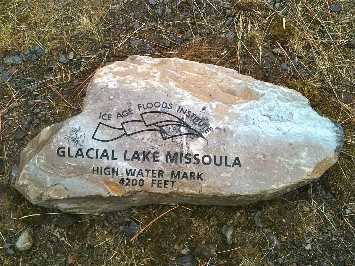
In what is now western Montana, during the last Ice Age, a finger of the Cordilleran Ice Sheet crept south into the Purcell Trench valley. It dammed the Clark Fork River. The river backed up. Over decades, the water rose until it formed a lake stretching across several thousand square kilometers of mountain valley, filling to depths approaching 600 meters in places. At its maximum, Glacial Lake Missoula held an estimated 2,184 cubic kilometers of water: roughly equivalent to the combined volume of Lake Erie and Lake Ontario.
The dam holding all of that water was ice. And ice floats.
When the lake rose high enough, the pressure of water at the base of the dam exceeded the ice's structural strength. Meltwater found pathways beneath the glacier. The ice lifted. The water began to move. Once it started, nothing could stop it. The entire lake drained in approximately forty-eight hours.
The discharge rate at peak flow has been estimated by different researchers at between 17 and 21 million cubic meters per second — roughly ten times the combined flow of every river on Earth today. The water moved at speeds approaching 130 kilometers per hour. It carried boulders the size of houses. It stripped soil, loess, and vegetation down to bare basalt across an area of more than 16,000 square kilometers in eastern Washington. Then, over weeks or months, the lake refilled. Then the ice dam broke again.
This happened at least forty times over a span of roughly 2,000 years.
What the Floods Left Behind
The Channeled Scablands are the scar. They cover eastern Washington in a network of dry canyons, called coulees, carved into the Columbia River Basalt by floodwaters that had nowhere else to go. The basalt here is among the hardest rock on the continent. The floods cut through it anyway, in days.
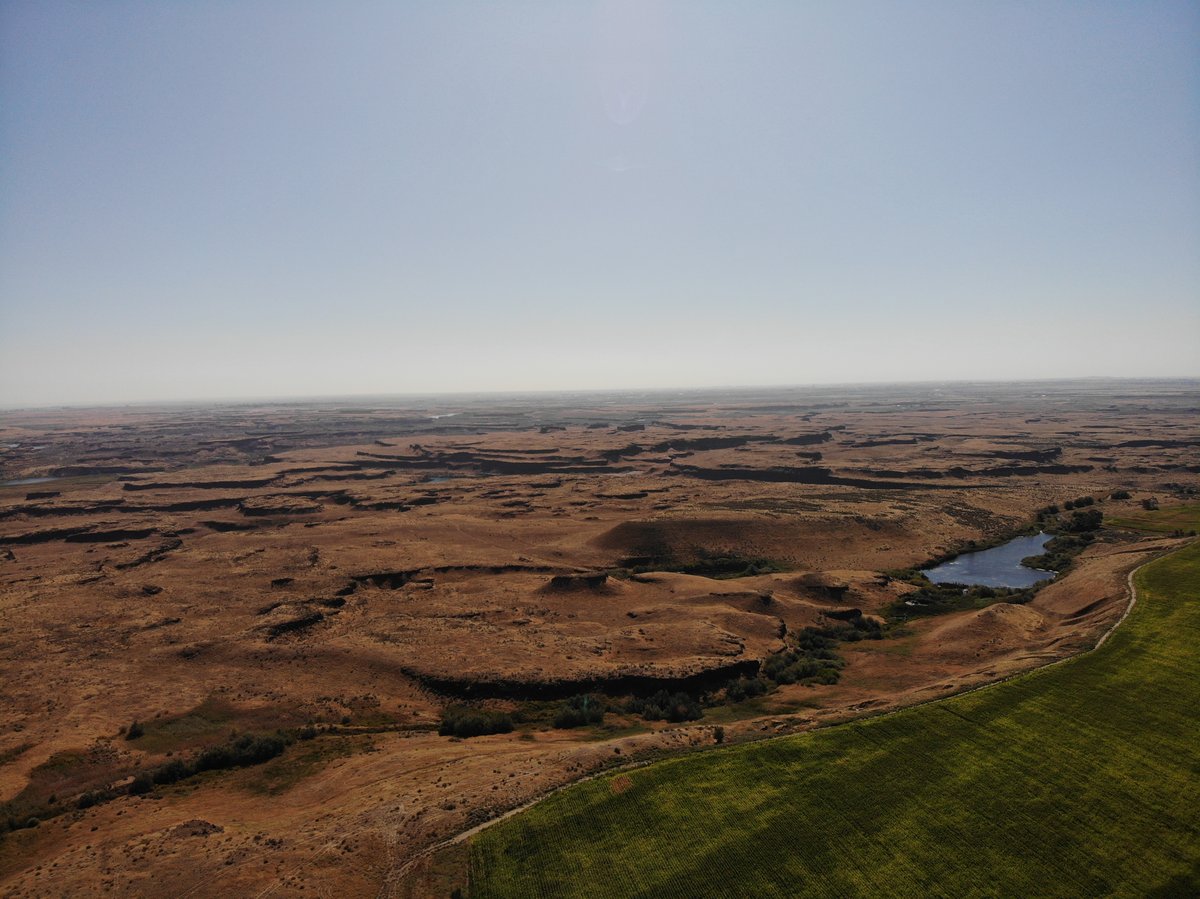
The features the floods left are unlike anything produced by ordinary river erosion. Pothole lakes, some over 100 meters across, were drilled into bedrock by vortices of sediment-laden water rotating at high speed. Coulees tens of kilometers long were cut in a matter of days. In the Quincy Basin, giant current ripples still exist, their crests standing up to 15 meters high and spaced hundreds of meters apart. At human scale they look like low rolling hills. Only from the air does the pattern become clear: these are ripples, the same structures you see in a sandy creek bed, scaled up by a factor of several thousand.
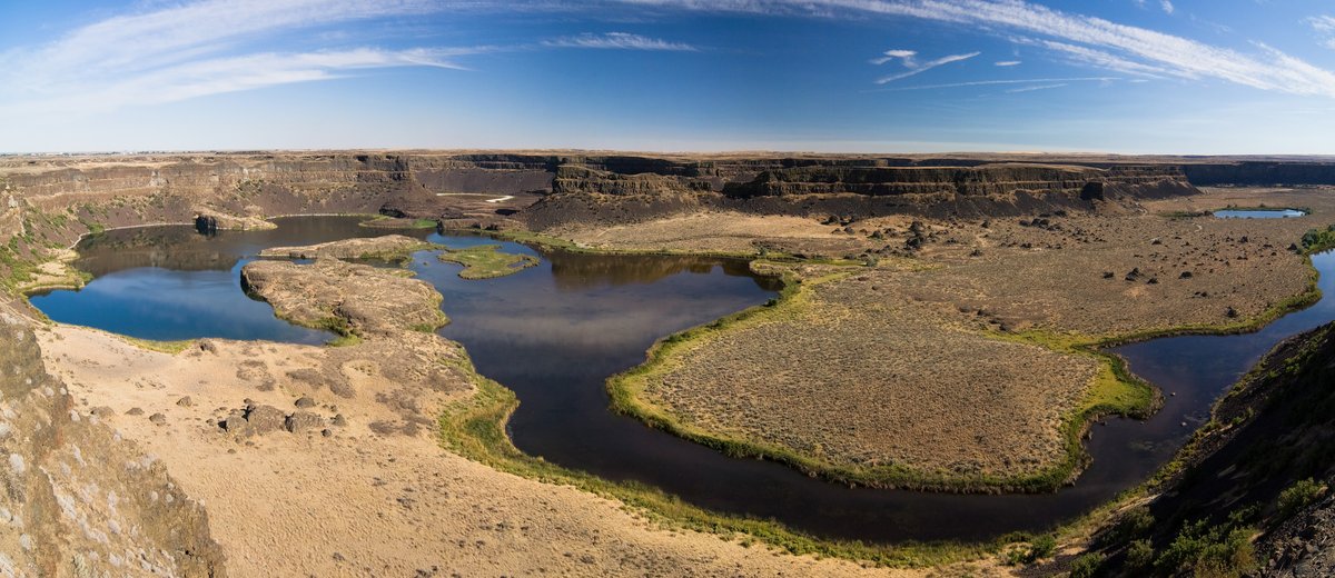
Dry Falls, in what is now Sun Lakes-Dry Falls State Park, is the ruin of a waterfall that was briefly the largest on Earth. At its peak, floodwaters poured over a cataract 120 meters high and nearly 6 kilometers wide — ten times the width of Niagara Falls. It operated for a matter of days, then went dry. It has been dry ever since. You can stand on the rim and look down into the plunge pool basin below, now a lake. The scale is difficult to process.
Erratic boulders, some weighing tens of tons, were carried hundreds of kilometers from their source formations in Montana and Idaho. They were frozen into icebergs calved from the glacier as the lake drained, transported by the floods, and deposited wherever the ice melted. Today these boulders sit alone in fields and hillsides, geologically foreign to the rock beneath them. In the Willamette Valley of Oregon, flood deposits reached depths of 30 meters or more, laying down the extraordinarily fertile soil that would later make the valley one of the most productive agricultural regions in the Pacific Northwest.
The Portland basin, where the Columbia and Willamette rivers meet, was submerged under hundreds of feet of floodwater during major flood events. Gravel bars deposited at the mouths of tributary valleys, where the floodwaters suddenly slowed, are still identifiable in the topography. The modern farmland and suburbs of the Portland metro area sit on material that arrived in a catastrophic two-day pulse from 700 kilometers away.
J Harlen Bretz and the Wrong Kind of Theory
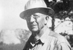
In 1922, a geologist from the University of Chicago named J Harlen Bretz made his first field visit to the Channeled Scablands. He was 40 years old, trained in biology before turning to geology, and he had spent years mapping the glacial geology of the Pacific Northwest. What he saw in eastern Washington did not fit any conventional explanation.
The scale of the features was wrong for any river. The coulees were too large, too abrupt, too interconnected. The dry waterfalls had no source valleys behind them. The potholes were drilled into bedrock in configurations that no normal streamflow could produce. Ripple marks appeared on valley floors at heights of hundreds of meters above the present river channels. Everything pointed to a single, violent, short-duration event of a size that had no precedent in the geological record.
In 1923, Bretz published "The Channeled Scabland of the Columbia Plateau" in the Journal of Geology. The paper proposed that the Scablands had been carved by a catastrophic flood of extraordinary scale. He was careful with his evidence. He documented specific features, described their dimensions, and argued that no combination of slow geological processes could produce what he was describing. He did not, at that point, know where the water came from. He simply argued the flood had happened.
The geological establishment rejected him immediately. And the rejection was not casual.
Forty Years of Uniformitarianism
The dominant framework in geology in 1923 was uniformitarianism: the principle, associated most closely with Charles Lyell, that geological change occurs slowly and continuously through processes still operating today. The catastrophism of earlier centuries, with its reliance on biblical floods and sudden transformations, had been decisively displaced. To propose that a vast landscape had been carved by a single catastrophic flood was, to many geologists, not just wrong but methodologically unacceptable. It smelled of the old catastrophism they had spent a century arguing against.
"Ideas without precedent are generally looked upon with disfavour and men are shocked if their conceptions of an orderly world are challenged."
— J Harlen Bretz, 1928
In January 1927, the Geological Society of Washington convened a special session to address Bretz's hypothesis. Six geologists presented competing explanations, each arguing that the Scablands could be accounted for by ordinary processes. Bretz later described it as an ambush. His critics did not deny the features he documented; they simply refused to accept that the explanation required anything as dramatic as a catastrophic flood. The meeting produced no resolution. It produced only a consensus that Bretz was wrong.
He continued to publish. He documented more features. He refined his arguments. He also had a problem he couldn't solve: he still couldn't identify a source for the water. Without that, the hypothesis had a critical gap. Where had all the water come from?
Pardee and the Answer in the Lake Bed
Joseph Thomas Pardee was a geologist with the U.S. Geological Survey. He had identified Glacial Lake Missoula in a 1910 paper, mapping the distinctive strandlines, the horizontal terraces cut into the Montana hillsides that mark old shorelines. He knew the lake had existed. He knew it had been enormous. And he had evidence that it had drained suddenly.
In 1940, Pardee presented his findings at a Geological Society of America meeting in Washington, D.C. The paper was published in 1942 in the GSA Bulletin under the title "Unusual Currents in Glacial Lake Missoula." It was, despite its restrained title, a devastating piece of evidence. Pardee had found giant current ripples on the floor of what had been the lake bed: sediment structures with wavelengths of over 150 meters and amplitudes of 15 meters. Features of that scale cannot be formed by slow settling of lake-floor sediments. They require a current of extraordinary velocity. In a lake, that means drainage. Sudden, catastrophic drainage.
Pardee's 1942 paper gave Bretz the source he needed. The ice dam holding back Glacial Lake Missoula had failed. The lake had drained. The floods had happened.
Pardee had held back from publishing these findings for years. He worked for a federal agency that operated by consensus, and the geological consensus was against catastrophism. His delay meant Bretz spent nearly two additional decades defending his hypothesis without the crucial supporting evidence his colleague had in hand.
How Many Floods
One of the things popular accounts most consistently get wrong about the Missoula Floods is the number. Most simplified versions describe a single event: the ice dam broke, the lake drained, the Scablands were carved. The reality is significantly stranger.
The Cordilleran Ice Sheet was a dynamic system. After each flood, the Clark Fork River continued to flow. Over decades, sediment and ice refilled the gap left by the collapsed dam. The lake refilled. Then the dam failed again. Between approximately 15,000 and 13,000 BC, this cycle repeated at least forty times, and possibly as many as one hundred, with an average interval of roughly 55 years between major floods. Each individual flood lasted perhaps two to three days. The cumulative effect was the Channeled Scablands.
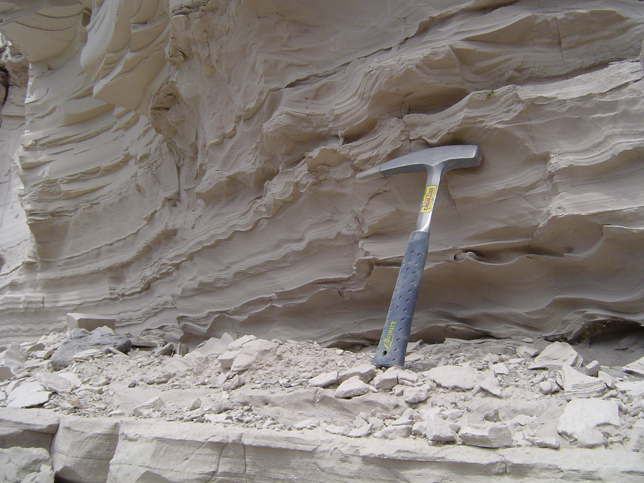
The evidence for multiple floods is visible in the stratigraphy. Flood sediment deposits in the Willamette Valley show distinct layered sequences, each flood event separated by soil development and organic material from the intervening periods. Palouse loess, the fine windblown soil that blankets much of eastern Washington, was redeposited between floods. Mud cracks and animal burrows appear between flood layers, indicating periods of drying and ecological recovery. The floods are not one event read in one layer. They are a library.
Vindication: 1965
The turning point came slowly. Through the 1950s, a few geologists began examining the Scablands more carefully and finding it difficult to account for the features without something very much like what Bretz had described. The ripples he identified were too large, too systematically oriented, too clearly hydrodynamic in origin to be dismissed.
In 1965, the International Association for Quaternary Research (INQUA) organized a field excursion to the Channeled Scablands. Geologists from around the world walked the coulees, examined the ripple fields, stood at the rim of Dry Falls. At the end of the trip, the consensus of the assembled international geological community was that J Harlen Bretz had been right.
Bretz was 83 years old. He received a congratulatory telegram from the field trip participants. His recorded response was characteristic: he expressed satisfaction that he had lived to see it.
In 1979, the Geological Society of America awarded Bretz its Penrose Medal, the highest honor in American geology. He was 96 years old. When informed of the award, he reportedly said: "All my enemies are dead, so I have no one to gloat over."
He died in 1981 at age 98. He had been proposing the catastrophic flood hypothesis for 58 years.
What Popular Accounts Get Wrong
The "single biblical flood" framing is the most common error. Documentaries and popular science articles routinely describe the Missoula Floods as a singular event. The mechanism, however, was iterative: a cycle of dam failure and reconstruction that played out dozens of times. No single flood carved all of the Scablands. The landscape is the cumulative product of repeated events.
One flood, not forty. Popular accounts routinely describe a single catastrophic event. The ice dam failed and reformed at least forty times, producing repeated megafloods over approximately 2,000 years. The Scablands are a cumulative record, not a single snapshot.
The Younger Dryas connection. The Missoula Floods are sometimes conflated with the Younger Dryas cold reversal that occurred around 12,900 years ago. These are related but distinct events. The Younger Dryas may have been triggered in part by large influxes of meltwater from the Laurentide Ice Sheet disrupting North Atlantic circulation, but the primary Missoula flood sequence predates and partially overlaps the Younger Dryas rather than coinciding with it precisely. The relationship is real but complicated.
The dates. "12,000 years ago" is a common shorthand, but the floods ran from approximately 17,000 to 15,000 years BP (before present), translating to roughly 15,000 to 13,000 BC. The sequence began earlier than the popular figure suggests and ended before the last glacial maximum had fully resolved.
Bretz's Penrose Medal date. The award is frequently cited as 1956. It was 1979. Bretz received a separate recognition in 1965 through the INQUA field trip vindication, but the Penrose Medal, the GSA's highest honor, came in 1979 when he was 96.
Mars and the Legacy of Catastrophism
The rehabilitation of Bretz's hypothesis had consequences beyond the Channeled Scablands. When Mariner 9 reached Mars in 1971 and returned the first detailed images of the Martian surface, geologists recognized features they had seen before. The Kasei Valles, the Ares Vallis, and other outflow channels on Mars are vast drainage features with morphologies consistent with catastrophic flooding: scoured bedrock, streamlined islands, giant ripple-like bedforms, and anastomosing channel networks. The scale is even larger than the Scablands, but the origin is analogous.
The framework for interpreting these features came directly from Bretz's work. Victor Baker, one of the geologists who had done the most to quantify the Missoula Floods through the 1970s and 1980s, was among those who applied the catastrophic flood model to Martian geology. The Bretz hypothesis, once dismissed as unscientific catastrophism, became a tool for reading the surface of another planet.
It is worth considering the irony. The objection to Bretz's hypothesis in 1923 was that catastrophic floods were not how geology worked. Geology worked slowly, uniformly, in ways still operating today. The evidence in eastern Washington said otherwise. And the evidence on Mars, recognized a half-century later, said it again: catastrophic floods happen. They leave records that are unmistakable once you know what to look for. Bretz knew what to look for in 1923. It took the rest of the field another four decades to follow.
The Scablands Today
The Channeled Scablands are still there. Eastern Washington has the topography of a drained ocean floor because, for a few days every 55 years over a span of 2,000 years, that is essentially what it was. The coulees are dry. Dry Falls is empty. The giant ripples near Soap Lake are now so subtle at ground level that most people drive past them without noticing. From the air, the pattern is unmistakable.
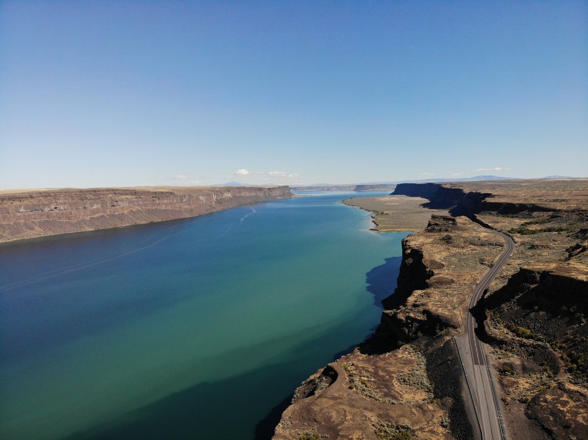
The Ice Age Floods National Geologic Trail, established by Congress in 2009, follows the flood path from Montana to the Pacific. Interpretive sites mark the major features: Dry Falls, the Drumheller Channels, Palouse Falls, Wallula Gap where all the floodwaters converged into a single bottleneck on their way to the sea. Palouse Falls itself, still active, pours over a basalt cliff into a canyon that the floods carved in a matter of days from rock that had stood for millions of years.
The high water marks of Glacial Lake Missoula are visible on the hillsides around Missoula, Montana: a series of horizontal terraces cut into the slopes at successively lower elevations as the lake drained and reformed at different levels across the flood cycles. They are among the most direct physical records of the events, scratched into the landscape by a lake that no longer exists, held back by a dam that failed forty times and is gone entirely.