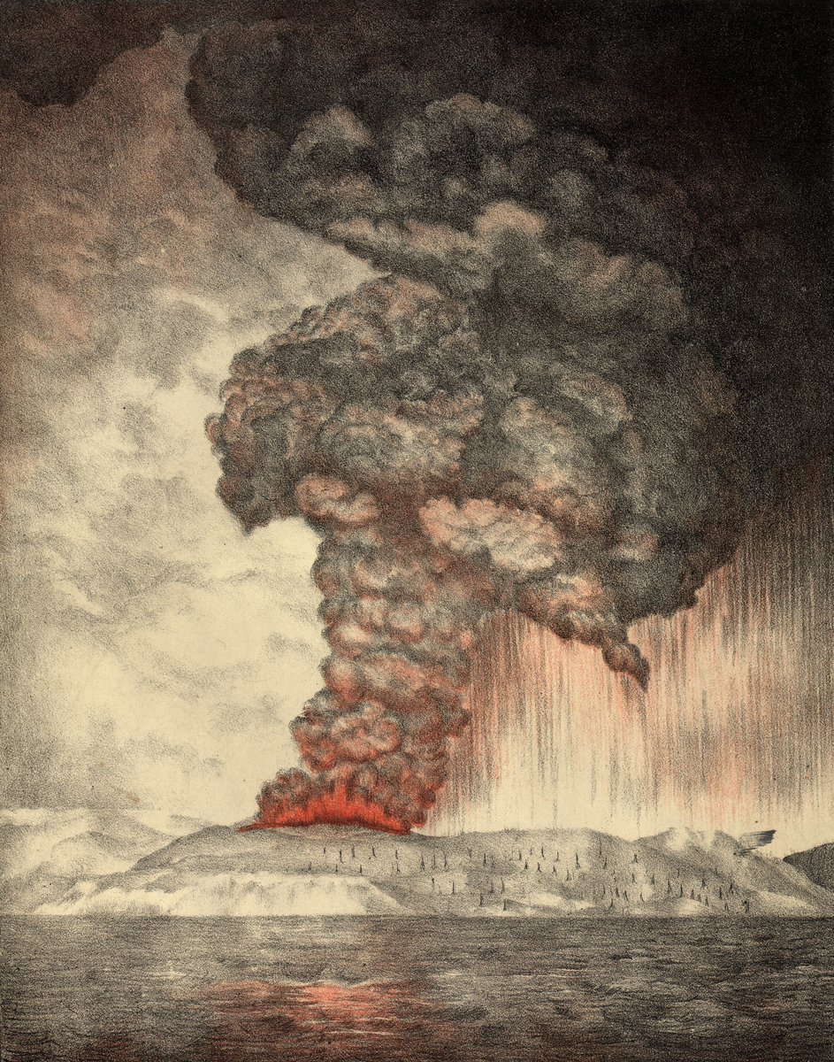
The Sunda Strait had been watching Krakatoa for months. The island had been erupting since May 20th, steam columns rising to 36,000 feet, ash falling on Batavia 160 kilometres away. Ships were logging it in their journals. Scientists were visiting and collecting samples. The Dutch colonial administration had taken careful scientific interest in the activity. Nobody was evacuating the coastal towns.
That is the first thing to understand about what happened on August 27, 1883. The catastrophe was not invisible beforehand. It was a surprise only in the sense that nobody understood what the scale of it might be. A volcano is a volcano. Krakatoa had erupted before, in 1680. The boats kept sailing through the strait. The towns of Merak and Teluk Betung had been there for generations.
The Island's Geometry
Krakatoa sits in the middle of the Sunda Strait, roughly 40 kilometres from the Javan and Sumatran coastlines on either side. In 1883 it was three connected volcanic peaks on a single island: Perboewatan in the north, Danan in the centre, and Rakata rising 820 metres in the south. The island was uninhabited but well-known. Ships used it as a navigational landmark.
The strait beneath the island is in places less than twenty metres deep. The broader region sits on the Sunda Arc, where the Indo-Australian plate subducts beneath the Eurasian plate. The magma produced by that process is volatile-rich: when it encounters seawater at speed and scale, the result is an explosion rather than a flow. Krakatoa was configured in precisely the worst possible way for what was about to happen.
The August 27 Explosions
5:30 AM — first major explosion
6:44 AM — second explosion
8:20 AM — third explosion
10:02 AM — fourth explosion: caldera collapse, phreatomagmatic detonation
Estimated energy released: ~200 megatons of TNT
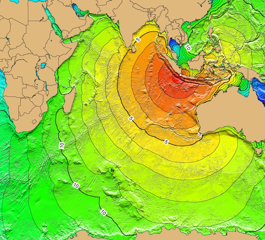
Pressure wave: circled the globe 7 times, recorded on barometers for 5 days
10:02 AM
At 10:02 AM on August 27th, the northern and lower portions of the island collapsed into the emptied magma chamber below. The sea floor dropped. The sea rushed in. When seawater meets a superheated magma chamber at that scale and that speed, steam expansion is so violent and instantaneous that it functions as a detonation. The energy released was later estimated at roughly 200 megatons of TNT — approximately four times the yield of the most powerful nuclear weapon ever tested.
The explosion was not merely the loudest sound in the 1883 world. It is the loudest sound in recorded human history.
Not estimated, not approximated. Recorded and measured on barometric instruments at observatories on four continents. The pressure wave traveled outward at the speed of sound in all directions simultaneously, circling the globe not once but seven times. Its signature was still visible on barometers in Europe and North America on September 2nd, five days later.
What "Heard in Australia" Actually Means
At the Rodriguez Island police station near Mauritius, 4,800 kilometres away, an officer filed a formal report about "guns firing from the direction of the northwest." He had heard Krakatoa. The sound had taken approximately four hours to arrive.
In Perth and on Rottnest Island, Western Australia, residents heard a series of detonations and assumed a ship in distress was firing signal guns. Some came to the coast to look for the vessel. There was no vessel.
In Sri Lanka, horses panicked in the streets of Colombo. In the dead centre of the Australian continent, Alice Springs, the sounds were logged and the date recorded. In western Java, police and military officers dispatched urgent reports about artillery bombardment, each unaware that the explosions were coming from the strait itself.
Witnesses closest to the explosion described a sound so loud it caused physical pain. At Batavia, 160 kilometres away, windows were shattered across the city.
The Waves Killed Everyone
The caldera collapse that produced the sound also displaced the floor of the Sunda Strait. The first major tsunami struck the Javan coast around 10:20 AM, eighteen minutes after the main explosion, at heights reaching 30 metres in some locations.
Merak, on the Javan coast, was struck by a wave approximately 15 metres high that erased the town. Teluk Betung on the Sumatran coast was hit by a wave over 10 metres. Between them, these two towns accounted for thousands of the dead.
The Dutch colonial gunboat Berouw was anchored in the Lampung River near Teluk Betung. The wave carried it 2.5 kilometres inland and deposited it in a forest at an elevation of nine metres above sea level. All 28 crew members were lost.
Of the approximately 36,000 who died in the Krakatoa disaster, roughly 90 percent drowned in the tsunamis. The eruption that produced the loudest sound in history was, in terms of its killing, almost incidental.
What the Sky Became
The explosion injected approximately 25 cubic kilometres of ash and sulphur dioxide into the stratosphere. Within weeks, the finest particles were circulating globally. Through 1883 and into 1884, blood-red sunsets were documented from Norway to New Zealand. Observers across Europe and North America reported sunsets of extraordinary crimson intensity, greenish sky tints at midday, and afterglows that lasted long past dark.
Global mean temperatures dropped approximately 1.2 degrees Celsius in the year following the eruption. The Royal Society in London compiled a 494-page report in 1888 on the atmospheric effects alone.
Edvard Munch painted "The Scream" in 1893, a decade after Krakatoa. His diary describes standing on a path outside Kristiania when "the sky suddenly became blood red." Atmospheric scientists have noted that the Krakatoa aerosols had largely settled by 1887, and the connection is uncertain. What is certain is that unusual optical phenomena over Norway in the 1880s were extensively documented and partly attributable to Krakatoa's stratospheric injection. Whether Munch's sky was one of them remains unresolved.
The Island Came Back
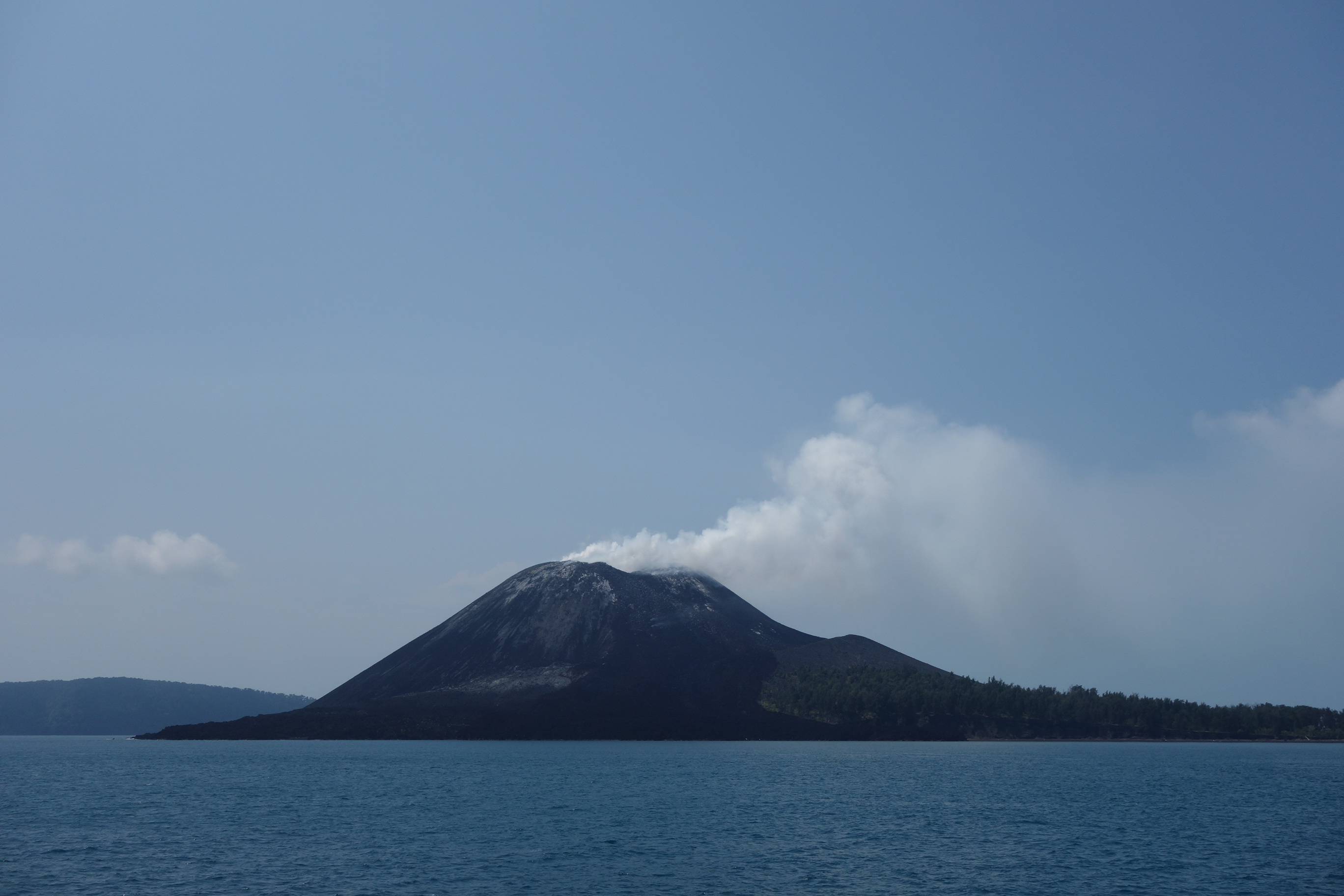
The eruption largely destroyed the island. What remained was the southern third: the peak of Rakata, rising alone from the sea. For decades, a roughly circular reef and caldera marked where the rest had been.
In 1927, fishermen reported steam rising from inside the old caldera. By 1928, a new island had broken the surface. Dutch geologists named it Anak Krakatau, "Child of Krakatoa." It grew intermittently through the twentieth century, adding material with each eruption cycle.
In December 2018, Anak Krakatau's southwestern flank collapsed into the sea during an eruption. The collapse generated a tsunami that struck the coasts of Java and Sumatra without warning, killing 437 people. It was a Saturday evening. People were attending a concert on the beach.
Anak Krakatau is monitored continuously by Indonesia's Centre for Volcanology and Geological Hazard Mitigation. The same geological configuration that produced August 27, 1883, exists there today, at smaller scale. A volcanic island. A shallow strait. A magma system underneath. A sea floor capable of displacement.
It is not finished.
Works Cited
- 1883 eruption of Krakatoa — Wikipedia
- Krakatau — Smithsonian Global Volcanism Program
- Royal Society of London (1888). The Eruption of Krakatoa and Subsequent Phenomena. Report of the Krakatoa Committee.
- When Krakatoa Exploded, the Sky Turned Red Across the World — Smithsonian Magazine
- Winchester, S. (2003). Krakatoa: The Day the World Exploded. Harper Perennial.
- Zerefos, C.S. et al. (2007). Atmospheric effects of volcanic eruptions as seen by famous artists. Atmospheric Chemistry and Physics, 7, 4027–4042.
- Krakatau — USGS Volcanoes
- Tsurutani, B.T. et al. (2003). The extreme magnetic storm of 1–2 September 1859. Journal of Geophysical Research, 108(A7).
- 2018 Sunda Strait tsunami — Wikipedia
- Krakatoa's Explosion — National Geographic