Four and a Half Minutes
Most earthquakes are over before you understand one has started. The shaking lasts ten seconds, maybe twenty, and then the world is still again. That is the part of this story that people who were there still cannot make others believe. The Great Alaska Earthquake did not last seconds. It lasted roughly four and a half minutes, long enough to stand up, fall down, crawl to a doorway, lose your nerve, and find it again, all while the ground was still rolling.
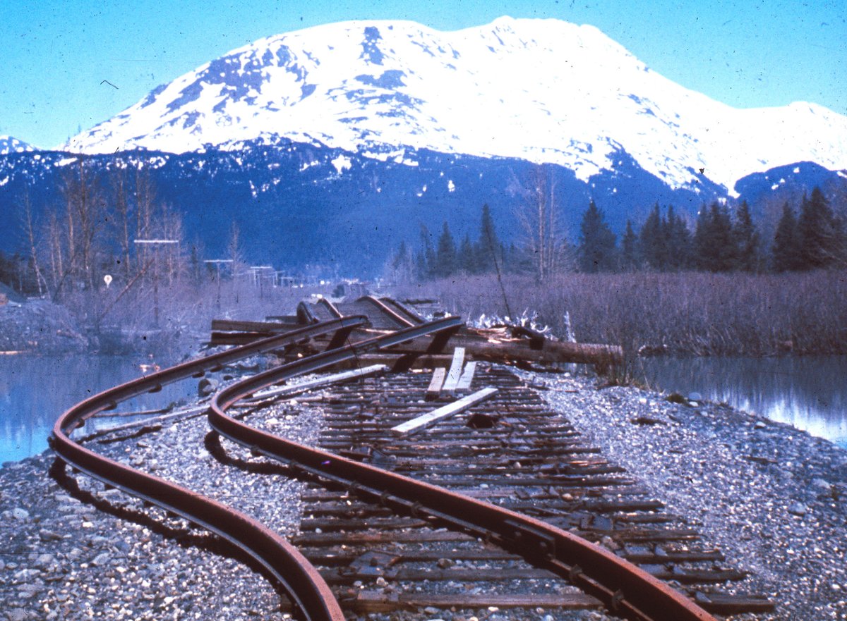
It struck at 5:36 in the evening on Good Friday, March 27, 1964. The epicenter sat in Prince William Sound, about 75 miles east of Anchorage, with the rupture beginning roughly 15 miles down. There the Pacific Plate lurched north and dove beneath the North American Plate along the Alaska-Aleutian subduction zone. A section of fault around 580 miles long broke in a single event. The moment magnitude was 9.2. That number is worth holding still for a moment: it is the most powerful earthquake ever recorded in North America, and the second most powerful ever measured anywhere on Earth since instruments existed to measure them. Only the 1960 Chilean quake was larger.
The energy was enough to make the entire planet ring like a struck bell, vibrating at frequencies too low to hear. People felt the shaking in Seattle, twelve hundred miles away, where the Space Needle swayed. What follows is what that energy did when it reached the surface.
The Ground Gave Way in Anchorage
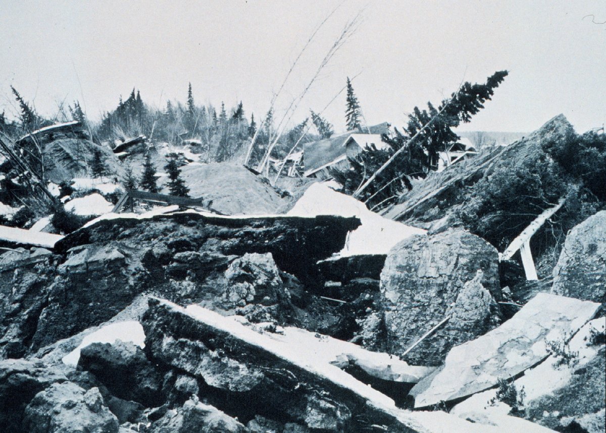
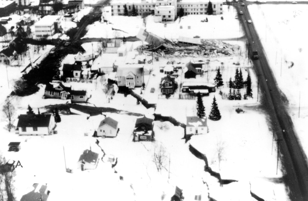
Anchorage took its worst wounds not from the shaking itself but from what the shaking did to the dirt underneath it. Parts of the city are built on bluffs of sandy soil sitting on top of a layer of marine clay called the Bootlegger Cove clay. When the violent, sustained motion hit that clay, it lost its strength and behaved like a liquid. Whole shelves of land then slid sideways toward open ground or toward the water, carrying the houses on top of them.
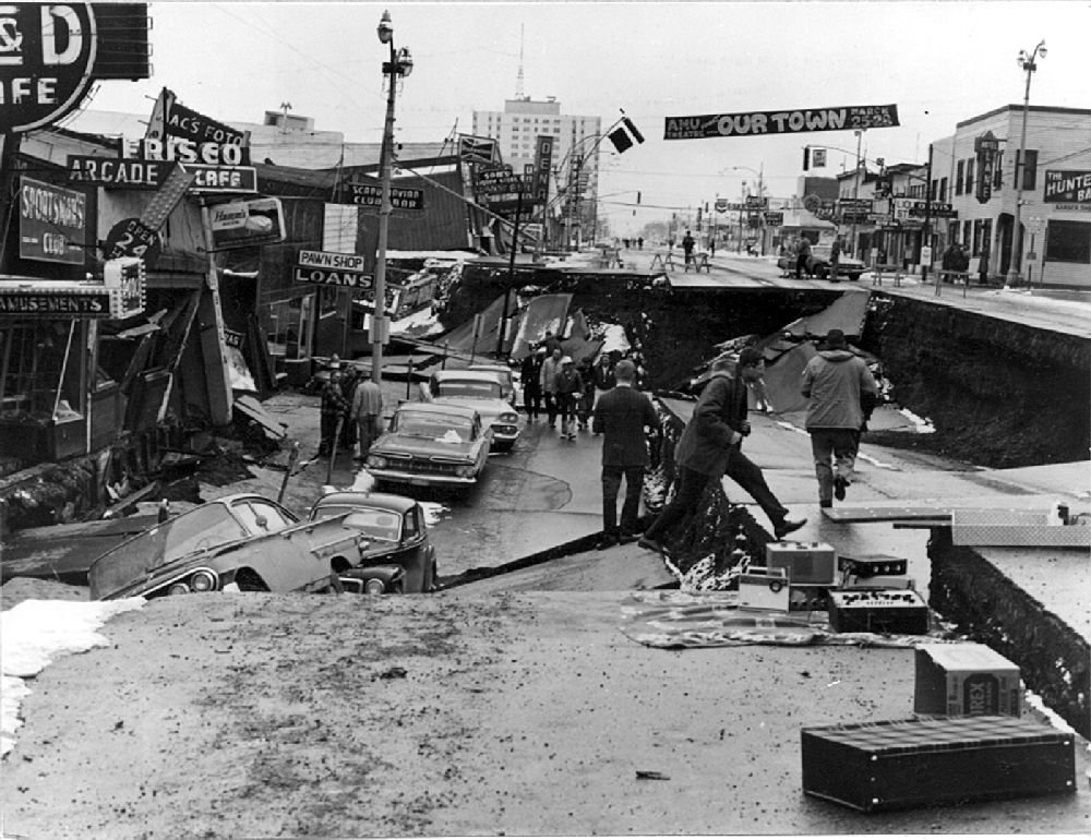
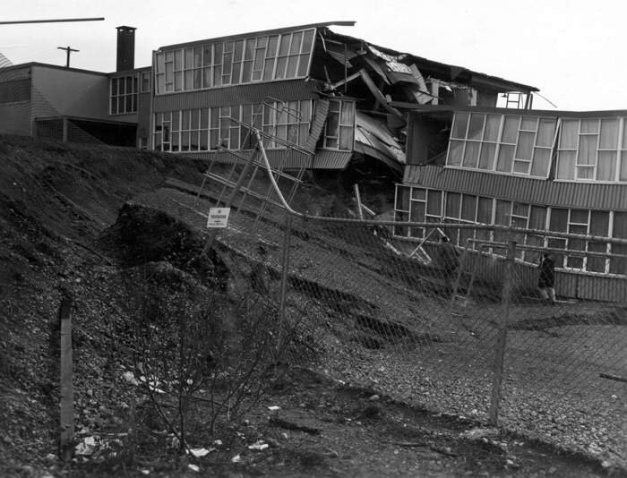
The most famous failure happened at Turnagain Heights, a comfortable residential neighborhood on a bluff above Cook Inlet. The bluff broke into a chaos of tilted blocks and collapsed toward the sea, destroying about 75 homes. Survivors described being carried on lawns that were folding like cloth. Downtown, Fourth Avenue dropped along a line down its middle, leaving one side of the street a full story below the other. The L Street slide carried a section of the city block sideways. Government Hill School, built across the head of a slide, was torn into pieces.
There is a small mercy buried in the timing. It was a holiday evening, schools and offices were empty, and downtown Anchorage was quiet. Had Fourth Avenue and Government Hill School failed at midday on a Tuesday, the toll in the city would have been far worse. As it was, the shaking killed remarkably few people directly. The killing happened somewhere else, and it had already started before the ground in Anchorage stopped moving.
The Sea Did the Killing
The earthquake heaved the floor of the ocean, and in the deep, steep-walled fjords of the Alaskan coast it did something worse. The shaking shook loose enormous masses of underwater sediment at the heads of the bays, and those submarine landslides shoved the water aside. The result was a series of local tsunamis that arrived not in the hour or two it takes a tsunami to cross open ocean, but within minutes. There was almost no warning, because the wave was born a few hundred yards from the dock.
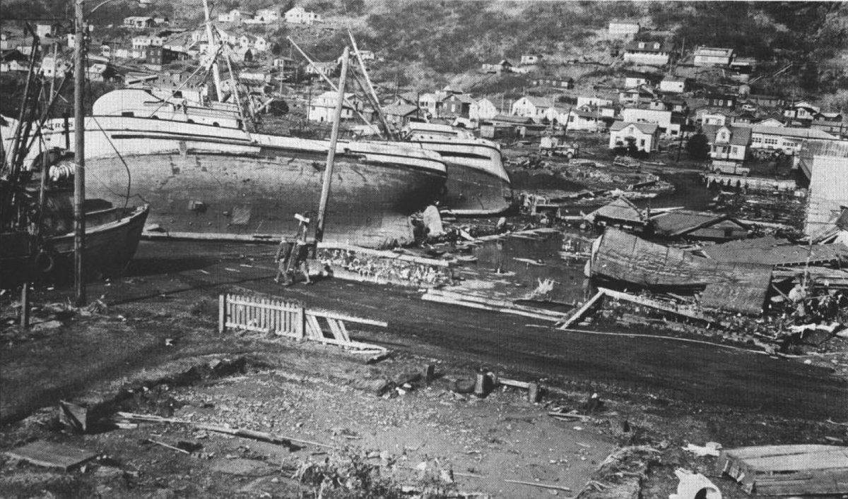
At Valdez, the freight ship Chena had tied up at the town dock late that afternoon, and townspeople, including children, had come down to watch it unload. When the quake hit, the underwater face of the delta the town was built on collapsed and took the waterfront with it. Valdez lost more residents than any other community that day, and the town was later abandoned and rebuilt on more stable ground four miles away. At Seward, a thousand-yard stretch of waterfront slid into Resurrection Bay, and burning oil from ruptured tanks spread out over the water that then washed back through the town.
The hardest blow, proportionally, fell on Chenega, a small Alaska Native village in Prince William Sound. A wave estimated at around 90 feet struck within minutes. The village lost 23 of its roughly 76 people, nearly a third of everyone who lived there. The survivors did not rebuild on the same spot.
The main tsunami, the slower one generated by the tectonic uplift itself, then rolled south across the Pacific. It still had the strength to kill thousands of miles from Alaska. At Crescent City, California, the waves destroyed much of the waterfront business district and killed ten people. Four children camping with their parents at Beverly Beach State Park in Oregon were swept away in the night. This is the detail most retellings get backwards, so it is worth stating plainly: most of the people who died that day were killed by the fast local landslide-waves in Alaska's own bays, not by the famous ocean-crossing tsunami.
| Measure | Figure |
|---|---|
| Date | Good Friday, March 27, 1964, 5:36 PM AKST |
| Magnitude | Mw 9.2 (2nd largest ever recorded) |
| Duration | ~4.5 minutes |
| Fault rupture | ~580 miles long |
| Max uplift | ~38 ft (Montague Island) |
| Max subsidence | ~8 ft |
| Deformed area | ~185,000 sq mi |
| Deaths | ~131 (sources range 129–139) |
| Most from | Local landslide tsunamis (~119) |
Water Sloshed in Forty-Seven States
You did not have to be near Alaska to register that something enormous had happened. As the planet rang, water in lakes, rivers, and wells across the continent began to slosh back and forth in a motion called a seismic seiche. Water-level recorders picked it up in 47 states. The only ones that stayed quiet were Connecticut, Delaware, and Rhode Island.
The sloshing was strongest along the Gulf of Mexico, where the geology focused the long, slow waves of the quake. In the bayous and harbors of Louisiana and Texas, the water heaved hard enough to snap boats from their moorings and sink them. This is the image that opens our episode, and it is the one people find hardest to believe: a fishing boat going under in a Louisiana harbor because the ground tore loose three thousand miles away in Alaska. More than 850 measuring stations across North America caught the seiche, and a handful as far away as Australia.
"The earth didn't move up and down so much as side to side. It was impossible to stand during the worst of the shaking. Lots of roads had fissures across them, and some were wide ones."
— Alice Arwezon, Anchorage
The Earthquake That Proved Plate Tectonics
In 1964, the theory of plate tectonics was not yet settled science. The idea that the Earth's surface was broken into rigid plates that slowly collided and dove beneath one another was argued over, not assumed. The Great Alaska Earthquake became one of the pieces of evidence that ended the argument, and the person who read that evidence was a USGS geologist named George Plafker.
Plafker spent the months after the quake working his way along hundreds of miles of shoreline by boat, helicopter, and float plane. His method was elegant and low-tech. The coast was lined with barnacles, mussels, and seaweed that live only within a narrow band around the tide line. Wherever the land had risen, those organisms were now stranded high and dry above the water. Wherever it had sunk, they were drowned. By mapping the band of dead sea life, Plafker measured exactly how much the land had moved: up by as much as 38 feet in places, down by as much as 8 feet in others.
The pattern he found, uplift out toward the ocean and subsidence inland, was the unmistakable fingerprint of a fault sloping down and inland beneath the continent. In 1965 he argued that the quake was caused by the Pacific sea floor thrusting underneath Alaska. That is subduction, described from its evidence before most of the field had accepted the word. The Great Alaska Earthquake gave geologists a grand, measurable example of a subduction zone caught in the act, and it helped push the plate-tectonics revolution over the line.
What It Left Behind
The disaster rewrote how the country prepares for the next one. There was no real tsunami warning system for the Pacific coast of North America in 1964, which is part of why the waves reached Crescent City with so little notice. The response built one. The center that now watches for tsunamis along the entire West Coast and Alaska grew directly out of this event, and it sits in Palmer, Alaska, not far from where the ground tore loose. The quake also drove the modern study of earthquake hazards in the United States, from better building codes to the seismic networks that track the ground today.
The toll itself remains slightly unsettled, which is its own kind of honesty. The most cited figure is around 131 dead, but careful sources land anywhere from 129 to 139 depending on how the far-away tsunami deaths are counted. For a magnitude 9.2 event that leveled neighborhoods and crossed an ocean, that the number is so low at all is down to the empty schools and the holiday quiet.
You can still stand on the wreckage. Earthquake Park in Anchorage is laid out across part of the Turnagain Heights slide, and the ground there is still hummocked and broken, frozen in the shape it took in those four and a half minutes. The interpretive signs explain not just what happened to the houses, but how a geologist reading dead barnacles on this coast helped prove how the planet works. Valdez, Chenega, and Girdwood stand on new ground, rebuilt away from the water that took the old towns. Sixty years on, the people who were children that evening still describe it the same way: not as a memory, but as something seared in that feels like it happened yesterday.