In the coastal villages of Japan's Iwate Prefecture, the night of January 27, 1700 arrived without warning. No shaking. No rumbling. Just the sea, behaving strangely — pulling back and then returning as a wall of water. Houses flooded. Boats wrecked. In the village of Kuwagasaki, thirteen houses were destroyed. Officials wrote it all down carefully, noting the timing and the damage and the one detail that made no sense: there had been no earthquake.
In Japan, you learn from childhood that a big wave follows a big shake. Coastal communities read the ground the way sailors read the sky. If the sea withdraws suddenly, you run. But nobody had felt anything that night. The wave had no parent. Officials filed their reports and called it what it was: an orphan tsunami.
Then they filed it away, and the mystery sat untouched for nearly three hundred years.
What Was Actually Happening Under the Pacific
The Cascadia Subduction Zone is a 700-mile fault running parallel to the Pacific Northwest coastline, from northern California through Oregon and Washington and into British Columbia. It marks the boundary where the Juan de Fuca oceanic plate slides eastward and dives beneath the North American continental plate at roughly four centimetres per year. Because the two plates lock together rather than sliding smoothly, stress builds for centuries. Then it releases all at once.
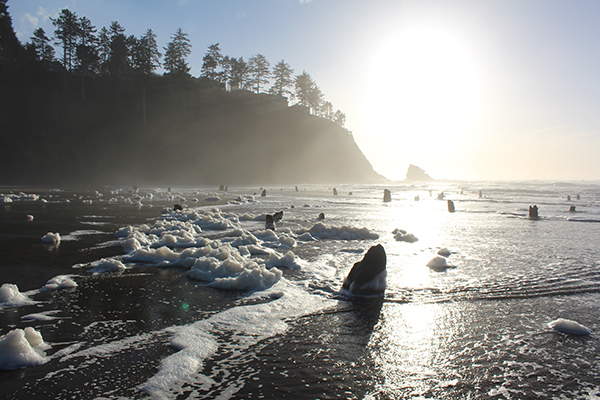
At approximately 9 PM on January 26, 1700, that's what happened. The locked plates gave way along the full length of the fault. The Juan de Fuca plate lurched roughly twenty metres relative to North America. The rupture ran seven hundred miles. The entire Pacific Northwest coastline dropped between one and two metres almost instantaneously. Forests at the edge of tidal marshes suddenly found themselves below the waterline. The ocean flooded in. The trees died standing upright, preserved in the sediment that drowned them.
These are what scientists now call ghost forests. They're still there.
Reading the Ground
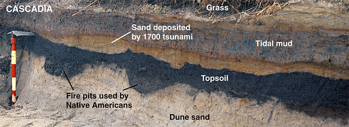
Brian Atwater, a USGS geologist, spent years in the 1980s and 1990s wading through coastal wetlands in Washington State. He was looking at the layers of earth exposed where rivers and tidal channels had cut through the banks. What he found, repeatedly, was a knife-edge transition: thriving salt marsh soil ending abruptly, buried beneath a layer of sand. Above the sand, dead forest. The pattern was identical at site after site along the Washington coast.
The sand layer was a tsunami deposit: fine sediment carried inland by a wave and dropped when the water retreated. The dead trees above it had drowned when the land dropped. The question was when.
That's where dendrochronology came in. By counting and comparing the ring patterns of the standing dead cedar trees against a master chronology of known-age samples, scientists determined that the trees had stopped growing at the end of the 1699 growing season. Their outermost ring was partial, meaning they were killed after spring 1699 had started but before spring 1700. The earthquake had happened in that window.
How Japan Provided the Exact Date
In the 1990s, Japanese seismologist Kenji Satake and his colleagues picked up the old orphan tsunami records and did something nobody had tried before. They worked backward. Using the wave heights recorded at multiple Japanese villages, the arrival times, and the physics of trans-Pacific wave propagation, they calculated where the waves had originated. The source had to be somewhere in the Pacific Northwest. The timing of the Japanese records, accounting for ten hours of ocean crossing, pointed to an origin around 9 PM Pacific time on January 26, 1700.
That matched the tree rings exactly.
Two entirely independent lines of evidence, one botanical and one archival, converged on the same night, to within hours. The Japanese had solved a Pacific Northwest earthquake using records nobody had looked at in three centuries. They published in 1996. The date January 26, 1700 — previously unknown — became a fixed point in the geologic record.
The 1700 Cascadia Earthquake
Date: January 26, 1700, approximately 9:00 PM local time
Estimated magnitude: 8.7 to 9.2
Rupture length: approximately 700 miles (1,000 km)
Plate movement: approximately 20 metres (66 feet)
Coastline subsidence: 1 to 2 metres across hundreds of miles
Wave arrival in Japan: approximately 9 hours later, 2–5 metres high
Tsunamis on the Pacific Northwest coast: estimated 10–30 metres
The Traditions That Were Already There
When the geological and historical evidence was published, Indigenous communities of the Pacific Northwest recognized it immediately. Their oral traditions had preserved accounts of the event for three hundred years.
The Huu-ay-aht people of Vancouver Island described a great earthquake and ocean wave that struck their settlement at Pachena Bay "on a winter evening shortly after residents had gone to sleep." Their account specifies that nobody had time to reach their canoes. "Everything then drifted away, everything was lost and gone." The Makah speak of a great nighttime earthquake with survivors being only those who immediately fled to high ground. The Quileute describe a flood powerful enough to carry canoes all the way to Hood Canal.
The scientists had confirmed the oral histories. The oral histories had been waiting for the scientists.
What Happens When It Goes Again
The Cascadia fault has produced at least 41 major ruptures in the past 10,000 years. Full-margin ruptures, the kind that happened in 1700, recur roughly every 400 to 500 years. As of 2026, 326 years have passed. The fault is locked. That is the dangerous state.
When the next full-margin rupture comes, the shaking will last three to five minutes — approximately four times longer than the 1906 San Francisco earthquake. Everything west of Interstate 5, Seattle, Tacoma, Portland, Eugene, Salem, Olympia, sits on ground that will behave differently from ground to the east. Waterlogged soils will liquefy. FEMA's modelled projections for a full-margin event include approximately 13,000 fatalities, 27,000 injuries, and 2.5 million people requiring emergency food and water.
Tsunamis reaching 30 metres (100 feet) will hit the coast within 15 to 30 minutes of the shaking. Most coastal communities in Oregon and Washington have no realistic evacuation window. As FEMA official Kenneth Murphy put it in 2015: "Our operating assumption is that everything west of Interstate 5 will be toast."
The 1700 event was not a warning, exactly. The fault was always going to do what it did. But the ghost forests, the sand layers, the Japanese records, and the oral traditions all preserved the same message across three centuries: it happened before. It will happen again. The only open question is when.
Works Cited
- 1700 Cascadia earthquake — Wikipedia
- Cascadia subduction zone — Wikipedia
- Satake et al., "Fault slip and seismic moment of the 1700 Cascadia earthquake" — Journal of Geophysical Research, 2003
- 1700 Cascadia Subduction Zone Earthquake — Pacific Northwest Seismic Network
- The Great Quake and the Great Drowning — Hakai Magazine
- Native lore tells the tale — University of Washington News
- Native American myths and geoscience — Slate
- Estimated Cascadia Impacts — Surviving Cascadia